|
||

|

|
|

|
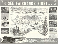
Rare separately published map of Alaska, promoting investment in the Alaska-Yukon-Klondike Gold Syndicate of Portland, Maine.
The officers of the Alaska-Yukon-Klondike Gold Syndicate are listed as:
- Hon. Fred Emery Beane, Pres (Ex-Mayor Hallowell, Me.)
- Col. Wm. J. Maybury M.D. Treas. (Surgeon General of Maine, Saco)
- C. E. Jeffrey, Vice Pres. (General Manager Live Insurance, Portland)
- William H. Jeffrey, Sec., (Editor and Publisher, Portland)
- Geo. H. Davis, Sup't of Mining, Late of Holy Cross Mines, Colorado
The map promises a number of clearly defined routes to the gold regions, including the "Teslin Trail" (also known as the Stikine Trail -- the "all Canadian Route which was supposed to include a Railroad line by 1899) and the "Back Door Route".
Back Door Route
The Back Door Route” was an all Canadian Route from the East, by way of railroad to Edmonton, then one of several portages to the Athabasca River, following a network of Hudson Bay Company posts to Great Slave Lake and the Mackenzie River to Fort MacPherson. From Ft. MacPherson, the traveler would go via the Peace River to reach a portage to one of the westward flowing streams, like the Porcupine or Stewart Rivers, to reach the Yukon either above or below the Klondike. “One great advantage of this route is that it is an organized line of travel, and the numerous posts of the Hudson’s Bay Company can furnish prospectors with ample supplies, enabling them to travel very light.”
As noted in the description of a similar map described in Persuasive Maps: PJ Mode Collection (Cornell University Library Digital Collection):
. . . The map uses large red letters to label the numerous "Gold Fields," along with fields of copper and coal. Dark red, dashed lines simplify the apparent access to these areas. . . .
When gold was discovered in the Yukon, there was an urgent demand for maps of the region, until then virtually unknown. "Consequently, maps of the Klondike and routes to the region were rushed to print and onto distribution with very little concern for accuracy or detail. . . . From the map producers' perspective, the main point was to use the pretense of objectivity - the map as a tool of legitimacy - in order to further specific economic interests" such as the sale of outfitting supplies, train tickets, steamer passage and hotel rooms (Burnette 2006, 46). They were simply "promotional pieces for those southern businesses particularly the transportation companies and large outfitters that stood to make fortunes servicing the needs of the Yukon-bound gold seekers." (Murray, 2011).
These maps are particularly misleading because "all the unexplored river valleys are labelled 'gold fields.' These enhancements made the area appear to be paved in gold when in fact there was only one field (albeit a very rich field) outside Dawson City." (Murray, 2008). Moreover, maps like this one that cover the entire northwestern part of the continent were essentially useless to the prospector on the ground|they "were life-threatening for novices of wilderness travel" who tried to follow them (Murray, 2011b)
Rarity
The map is apparently unrecorded.
We found a few bits of ephemera produced by the Alaska-Yukon-Klondike Gold Syndicate, but no evidence of this map.
![Partie du Cours du Fleuve de Saint Laurent depuis Quebec jusqu'au Cap aux Oyes [on sheet with] Carte du Cours du Fleuve Saint Laurent depuis Quebec jusqu'a la Mer en Deux Feuilles ... 1761](https://storage.googleapis.com/raremaps/img/small/55185.jpg)