|
||

|

|
|

|
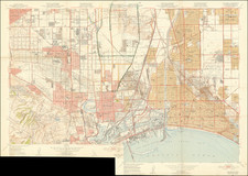
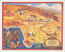
Large folding map of Los Angeles, issued as a promotional item for the Farmers and Merchants National Bank of Los Angeles.
The map depicts Los Angeles in the post-depression period, two years after hosting the 1932 Olympics and in the year that the Original Farmers Market at the Corner of Third Avenue and Fairfax began operating (marked by a massive open space which would become the Grove and Television City and the Farmer's Market. It is also the year before Griffith Observatory opened in Griffith Park.
most noteworthy element of this fine large format map is the demarcation in red of the available public transit lines in Los Angeles, including:
- Los Angeles Railway Cars
- Pacific Electric Railway
- Motorcoaches (Buses)
The on the verso are three 17 x 12 inch regional maps, with the depiction of the San Fernando Valley in the early 1930s quite interesting, including the early Steam and Electric Railways crossing the valley.
The detailed map of the Hollywood and Laurel Canyon is also quite interesting, showing the Pacific Electric Railway Route along Cahuenga Boulevard, over the hill and into the Valley.