The item illustrated and described below is sold, but we
have another example in stock. To view the example which
is currently being offered for sale, click the
"View Details" button below.


|
||

|

|
|

|
Stock# 63320
Description
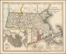
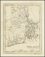
Nice example of Carey's map of Rhode Island.
A highly detailed map, which includes towns, roads, rivers, mountains, and many other details.
States of the Map
There are 4 states of the map.
- State 1 (1796): No roads
- State 2 (1801): Roads added map; from 'CONNECTICUT' into northern Rhode Island (and other changes)
- State 3 (1805): Circular town symbols have been added for Bri= , an unnamed town in Charlestown county and S. Ferry
- State 4 (1813): New place names have been added, including Wells, Scott's P, Pauwanget P., Beaver Tail, Price's Neck, Easton's Beach and East Passage.