


|
||

|

|
|

|
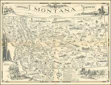
Fine early pictorial map of Montana, published by the state highway department.
The map was first published in 1936 by the Montana Chamber of Commerce as A map of Montana whereon is depicted and inscribed the pioneer history of the Land of Shining Mountains, with text verso by Robert H. (Bob) Fletcher. It was later re-issued in a larger format as a wall map.
The map focuses on the Montana frontier history during the Westward Expansion of the United States. Numerous detailed line drawings portray pioneers and Native Americans. Regarding the large illustrations surrounding the map, the legend in the lower margin states, "Border illustrations represent the major frontier industries: Trapping, Mining, Cattle and Sheep Raising, and Lumbering," and identifies symbols for fur posts, military forts, fights and battles, cities and towns, missions, historic markers and abandoned frontier towns. The map also indicates 11 historic trails from Lewis and Clark's route west in 1805, to the retreat of Chief Joseph's Nez Perces in 1877. In addition, it shows old freight and stage roads and "Indian trails over the Rockies" from after 1860, and the modern state highway system established in 1936. Beside the legend is a compass rose decorated with a Native American motif and an inset map of Yellowstone National Park. Mountain ranges are drawn in relief. Numerous smaller illustrations with captions also decorate the map.
Irvin "Shorty" Shope (Boulder, MT 1900 - 1978 Helena, MT). Shope was raised on a ranch in Montana, and fell under the influence of the western painter Edgar S. Paxson while still in high school. Between 1919 and 1930, Shope worked as a cowboy on Montana ranches, while studying art through a correspondence course.
![[Touring Map of California]](https://storage.googleapis.com/raremaps/img/small/76578.jpg)
![Beverly Hills Farmer's Almanack Map Part One [and] Beverly Hills Farmer's Almanack Map Part Two](https://storage.googleapis.com/raremaps/img/small/76945.jpg)

![[California in Miniature] Bird's-Eye View Map Showing Its Prominent Topographical Features, Location of Principal Cities, Towns and Points of Note, Also Lines of the Southern Pacific Company. 1898.](https://storage.googleapis.com/raremaps/img/small/63460.jpg)