This item has been sold, but you can enter your email address to be notified if another example becomes available.


|
||

|

|
|

|
Stock# 63233
Description
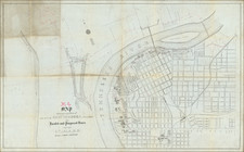
Scarce map of the Cumberland River from below Barboursville, Kentucky to the confluence of the Cumberland River and the Great South Fork, just above Nashville.
This survey was done to clear the Cumberland and open the route to make it more navigable for steamboats. This map includes four cross sections titled: Shadowen's Shoal, White Cliff Ripple, End of Smith's Shoals, and Long Shoal. It is decorated with an elaborate compass point and terrific lettering in the title, which exactly matches the fancy lettering used on steamboats.
This is an early work by Stansbury, who 18 years later commanded an important expedition to Utah.
Condition Description
Minor foxing.