|
||

|

|
|

|
Stock# 63200
Description
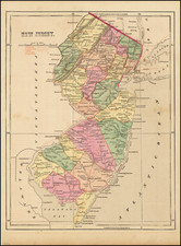
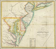
A nice example of Mathew Carey's map of New Jersey, from the American Pocket Atlas, first published in Philadelphia in 1796.
A highly detailed map, which includes towns, roads, rivers, mountains, and many other details.
States of the Map
The map is known in 4 states:
- State 1 (1796): No roads shown.
- State 2 (1801): Double ruled lines inserted between the title and scale bar. Place names added include M. Hamburg, Taunton, Alison, Leeds Lit Egg Harbor and Easton. Roads added
- State 3 (1805): Town of Leeds deleted. Towns of Bridgeton, Millville added and Dorcester changed to P.t Elizabeth. New roads added
- State 4 (1813): New towns added including Vernon, Hardwick, Pitt, Rariton, Cranbury, Hopewell, Swedesboro, Woods, Weymoth, Diving C. Tuckahoe Cr. and others. New roads added.
![[Pennsylvania, New Jersey, New York ] Speciel Land Charte von Pensilvanien, Neu Jersey, Neu York und von denen drey Land-schafften an dem Delaware Fl. In America in Englischer Spr. gedruckt A. 1749 In Europa duffgelegt in Teutsch Spr. zu Francfurt am M. A. 1750.](https://storage.googleapis.com/raremaps/img/small/51958.jpg)