|
||

|

|
|

|
Stock# 63172
Description
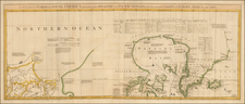
Korean War Confidential / Restricted Aeronautical Map of Hawaiian Islands
Detailed aeronautical map of the Hawaiian Islands, compiled by the U.S. Army Air Force Army Map Service.
The front side map illustrates the Hawaiian Islands and Midway Islands on a large scale, with profile recognition views and elevations, prepared to assist long range bombers and other military aircraft with visual navigation of the islands. On the verso is a map of the wider Northwestern Pacific, with the various airfields on the map identified in purple boxes.
Condition Description
Minor toning along folds. Printed on both sides.

![(Honolulu Stereoview) Honolulu from Punchbowl [Original stereocard photograph birdseye view of Honolulu, Hawaii]](https://storage.googleapis.com/raremaps/img/small/92950.jpg)
![Oahu [Hawaiian Islands 1:25,000]](https://storage.googleapis.com/raremaps/img/small/96167.jpg)