|
||

|

|
|

|
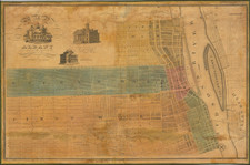
Rare View of Saint-Frédéric on Lake Champlain
Scarce map showing the fortifications at Fort Frederic or Crown Point, published in the Royal Magazine, issued shortly after the capture of Fort Frederic by the English, at the outset of the French & Indian War.
Fort Saint-Frédéric was a French fort built on Lake Champlain to secure the region against British colonization and control the lake. It was located in modern New York State, across the lake from modern Vermont, at the town of Crown Point, New York. The fort, whose construction began in 1734, was never attacked and was destroyed in 1759 before the advance of a large (more than 10,000 man) British army under General Jeffery Amherst.
The British Army and provincial militia then built Fort Crown Point, a vast fortification just southwest of the ruins of the French fort, starting in the fall of 1759. At the same time they built a fleet to gain military control of Lake Champlain and the 77-mile-long Crown Point Road across the Green Mountains to reach the Connecticut River. The garrison at Crown Point was captured by the Americans shortly after the outset of the American Revolution.