|
||

|

|
|

|
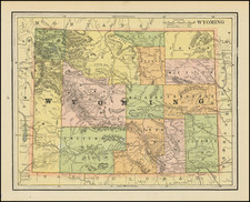
Rare first edition of this striking large format map of the West, published by Henry T. Williams, with handwritten notes, including a note relating to the notorious stagecoach robber, Black Bart, who operated in northern California and southern Oregon from 1875 to 1883.
The map is bound into a copy of The Pacific Tourist
Williams map of the west follows the Transcontinental Railroad west from Omaha to San Francisco, and along with a number of other early railroad lines in the west. The train stations along each route are shown and named, along with several proposed routes. The map is one of the best examples of the colorful and inviting maps used to promote tourist travel to the west.
The 1876 map is the first of two editions, the second of which was issued in 1877 (date in the title box). There are a number of changes in the second edition, including the following:
- Colorado (Colorado Central RR added with a loop down to Denver; southern terminus of RR extended to Ft. Garland)
- New Mexico (Projected RR line from Ft. Dodge Kansas to Santa Fe; Denver & Rio Grande and AT&SF RRs extended from Colorado to Santa Fe)
- Arizona (Castle Dome Mountains added, new place names added along the southern part of the Colorado River)
- California (Southern Pacific RR extended to Santa Monica, New RR line connecting Oakland, Martinez, Tracy & Lathrop
- Utah (proposed southern RR route from Denver to Salt Lake City removed)
An important map of the period, with remarkable contemporary annotations.
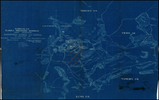
![Reconnaissance of San Clemente Harbor [with] Prisoner's Harbor . . . [with] Cuyler's Harbor Island of San Miguel . . . 1852](https://storage.googleapis.com/raremaps/img/small/102987.jpg)