


|
||

|

|
|

|
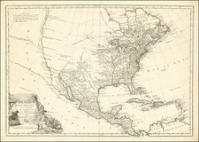
Including Boonesborough, Kentucky
Marvelous late 18th Century map of the United States, East and West Florida and part of Canada.
The map shows Georgia extending to the Mississippi River, pre-dating Mississippi Territory. Massive Western Territory dominates the Old Northwest Territory, with no suggestion of Jefferson's propositions for the dividing the region. Kentucky is named, but without a defined northern border. Both East and West Florida are shown, pre-dating the first US incursions into the region. Many Indian Tribes named, along with some Western Forts and several annotations. Chicago named (Chickago)
The map appeared in Cooke's Geography, published from about 1800 to 1817, apparently without changes to the map.
Boonesborough
The map shows the town of Boonesborough in Kentucky, originally founded as Boone's Station by the frontiersman Daniel Boone while working for Richard Henderson and Nathanial Hart of the Transylvania Company.
Boone led a group of settlers through the mountains from Fort Watauga (present-day Elizabethton in Tennessee), carving the Wilderness Road through the Cumberland Gap, and established Fort Boonesborough. Boone lived there from 1775 to 1779. The area was chartered Boonesborough in October 1779, one of the first English-speaking communities west of the Appalachian Mountains.
Boone successfully led his fellow settlers during the Siege of Boonesborough in 1778. He then moved to his son Israel's settlement at Boone's New Station near present-day Athens, Kentucky. Although the town served as a way-station for pioneers venturing further into Kentucky during the 1780s and 1790s, it never attracted a significant long-term population, and thus slowly declined and faded from maps.
![Le Colonie Unite Dell' America Settentrle. Di Nuova Projezione a S.S.E.E. Li Signori Riformatori Dello Studio Di Padovia . . . 1778 [12 sheets]](https://storage.googleapis.com/raremaps/img/small/90539.jpg)
![[The Final State] A New Map of North America, with the West India Islands, Divided according to the Preliminary Articles of Peace, Signed at Versailles, 20 Jan. 1783, wherein are Distinguished The United States and the Several Provinces, Governments &c Which Compose the British Dominions . . . 1794](https://storage.googleapis.com/raremaps/img/small/89085.jpg)
![(American Revolution) Geschichte der Revolution von Nord-America. Sammlung der besten Schriftsteller, welche die Geschichte, besondere Rechten, Sitten, und Gewohnheiten der Völker nach ihren Grundsätzen abgehandelt haben [with map:] Die Vereinigten Staaten von Nord=America. nach der Wm. Faden 1783. [History of the Revolution of North America. Collection of the Best Writers Who Have Discussed the History, Specific Laws, Customs, and Habits of the Peoples According to Their Principles [with map:] The United States of North America. According to Wm. Faden, 1783.]](https://storage.googleapis.com/raremaps/img/small/90124.jpg)