|
||

|

|
|

|
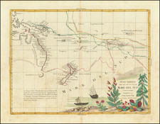
One of The Most Important Early Maps of New Zealand – With Significant Annotations
Finely executed map of New Zealand, the most important printed map of the islands in this period. This example has been extensively annotated with notes showing both coastal explorations and explorations in the interior parts of New Zealand.
The comprehensive set of pencil notes, which correspond to the active explorations of New Zealand in the period immediately before and after the publication of the map on August 2, 1841, suggests that the map was used by a senior governmental official or member of the New Zealand Company to compile contemporaneous data on the exploration of the island. It is also possible that this map was used to take notes for future cartographic changes, as many of the annotations shown here were integrated into later editions of Wyld’s map.
The annotations on the map are quite remarkable, with attention to detail on both the North Island and especially the South Island. As the majority of the annotations appear on the east coast of the South Island, we suspect that the annotations were made in the wake of reports from whalers, early surveying expeditions along that coast that took place soon after Port Nicholson was initially surveyed in 1839, and before the first plans of the New Edinburgh settlement, which eventually became Dunedin, beginning as early as 1843.
The map shows the entirety of the archipelago as it was known at that time. The most detail is close to the coast line, but Wyld is careful to indicate that the geography of the islands is far from set. For example, McDonnells Cove, near Hawke Bay on the east coast of the North Island, is labeled as “doubtful” (James Wyld Sr. had first published Thomas McDonnell’s map of New Zealand in 1834). The west coast of the South Island has an entire stretch of “Unexplored Coast.”
Paragraphs of sailing directions indicate the most populated and frequented parts of the coast. These are clustered around the Cook Straits and the North Island, where the majority of Maori and European missionaries and traders were clustered. Additionally, this was the primary area being colonized by the New Zealand Company. An inset of Port Nicholson, the New Zealand Company’s first settlement and today the city of Wellington, is included to the right. In the bottom right corner is an inset of the Chatham Group, an archipelago 800 kilometers east of the South Island.
In the top left corner is a title cartouche adorned with elegant script. The cartouche explains the primary sources for this map, which list Admiralty surveys from the English and the French, surveys of the New Zealand Company, and private surveys. The latter most likely refer to reports and observations from whalers and other traders who frequented the island by the 1840s. The first whalers came in the early 1790s and anchored at Dusky Sound. In the decades thereafter, whalers, mainly British, French, and American, ranged all around the islands, with stations especially on the east coast of the South Island.
The Admiralty surveys include, among others, those of James Cook and George Vancouver. The French surveys include those of de Surville, Marion du Fresne, Duperrey, and D’Urville. Wyld had a special relationship with the British Admiralty. As Hooker and Maling both note, there are several New Zealand manuscript charts in the Hydrographic Office Archives in Taunton that bear the note, “Copied from a rough tracing belonging to Mr Wyld.”
Annotations
The most remarkable detail of this example of the map are the pencil annotations scattered over the islands. They correct parts of the hydrography, suggest additional rivers and lakes, and offer coordinates for two points in the south. They were possibly drawn by a government official involved with the immigration debates over New Zealand, a New Zealand Company representative, or, most likely, a mapmaker eager to correct the map, perhaps even someone in Wyld’s shop.
East Coast of the South Island
The most annotated part of the map is the east coast of the South Island, which was best known by whalers who had stations along the coast. Wyld’s network of sea captains no doubt included whaling captains, and his maps surely benefited from their experiences in the South Pacific. Many of the corrections of the east coast appear in the 1846 reissue of the map.
Just south and across Cook’s Strait from Port Nicholson, a series of x’s line the shore, perhaps to indicate an obstruction. A squiggly line suggests a river and, following the coast southwest, Lookers On has been significantly redrawn. Several more rivers have been added north of Banks’s Peninsula, as has a lake, “Whihora,” just south of the peninsula. More corrections abound as the coastline snakes south. A set of coordinates is offered off of Port Otago, which is near where New Edinburgh, later Dunedin, would be settled. The corrections continue around the southern curve of the island.
Manganui River / Wai-Roa River
The northernmost penciled place name is Manganui, with a sketch of the Manganui River shown, flowing west from the Wairoa River about 30 miles west of Whangaeri. This area was apparently first trafficked for its lumber and flax around 1840. A bit further north, in the Mangakaia area on the Wai-roa River, is an illegible note, beginning with a "B".
Waicato River / Waihou River
A straight line is shown between the two rivers, beginning at the mouth of the Waihou (labeled “Wai-kahoa-rounga or R. Thames) and trending southwest. The line is suggestive of a further riverine connection or suggested pathway between the two waterways.
New Plymouth
The present map shows a pencil line between the area of Egmont Bay and that of New Plymouth. Whanganui, a bit farther south than the mark, was the site of a frontier mission established by Richard and Johanna Matthews on June 20, 1840 and became a settlement of the New Zealand Company. New Plymouth was first settled by British settlers after it was selected by Frederic Alonzo Carrington, chief surveyor of the New Plymouth Company, in March 1841. This pencil annotation looks to be an adjustment of the peninsula farther west.
Strategic X's
The map has a number of Xs marked along the coastline, perhaps suggesting obstructions at sea or likely places to place a settlement. These include:
-
False Bay: Just south of False Bay, and across the narrowing of the island from Auckland is a prominent X, perhaps suggesting a western point to begin an overland journey to Auckland.
-
Kati-Kati River: off the coast of Matakana Island (called simply low islands). This X may be suggestive of an accompanying longer note or generally the need to significantly update the map, given the inaccuracies along the coastline. This was the site of a missionary outpost.
-
Wangai-wai (Whangawehi) River: A hollow rock at Whangawehi was used as a baptismal font in 1842, and the Anglican archdeacon William Williams baptized 245 Māori there.
-
Hawkes Bay near Tangoio: This may relate to the first Christian chapel in the area of Tangoio, which is not named on this map, or nearby whaling stations at Moeangiangi and Whakaari.
The British in New Zealand to 1840
As the title cartouche mentions, the map also includes the surveying work of the New Zealand Company, established in 1839 to colonize New Zealand, as well as the New Plymouth Company, established in 1840 and merged with the New Zealand Company in April 1841.
The roots of the company go back further. The British first settled permanently on New Zealand when missionary activity began there under the auspices of the Church Missionary Society. Samuel Marsden, William Hall, Thomas Kendall, and John King were the first missionaries; Marsden gave the first sermon in New Zealand on Christmas Day 1814.
By 1831, there were enough European settlers to cause considerable consternation on the part of the Maori leaders. Thirteen Northern chiefs petitioned King William IV for protection, which the Crown granted. Two years later, the British Resident, a consular position, arrived and built a house in Waitangi. In 1835, the Resident, James Busby, drafted He Wakaputanga o te Rangatiratanga o Nu Tirene, the Declaration of Independence of New Zealand, which placed the sovereign power of the land with the Maori and their hereditary chiefs. By 1839, 52 chiefs had signed the declaration.
In the meantime, the British, who had not sanctioned the declaration, decided to begin formally colonizing New Zealand in 1837, the same year discussions began to form the New Zealand Company from a previous venture, the New Zealand Association, which failed to gain a royal charter. The British government appointed William Hobson to serve as Consul, under the authority of the Governor of New South Wales. Hobson was to oversee the purchase of land from the Maori.
By 1840, there were roughly 2,000 Europeans living in New Zealand, the majority single men—whalers, traders, and missionaries—and 7 of 10 of them were of British descent. They usually arrived via Sydney, in New South Wales.
The New Zealand Company and James Wyld
At the same time the government was appointing a Consul, the first New Zealand Company ship had set sail for the islands. The Tory was to survey and buy land for a settlement, which was decided to be at Port Nicholson, the inset on this map. The first settlers arrived in Port Nicholson in January 1840, having been attracted as laborers by exaggerated pamphlets and propaganda published by the Company.
Later in 1840 a group of surveyors of the New Zealand Company left Wellington and went up the west coast of the North Island. They mapped all the way as far as present day New Plymouth, which is not named on this map. However, the present map does show pencil annotations in this region, along with an illegible note just south of where New Plymouth should appear on the map.
The original report of this survey is in the Public Records Office, Kew, London, but the map which is supposed to have accompanied the report is now lost. This expedition was the first time any Europeans had explored by land along the west coast, with the results clearly depicted on Wyld's map.
This indicates that Wyld was almost certainly the first mapmaker with access to the original surveyors’ report and the now lost map. For example, the map contains for the first time the names of the Maori settlements and the names of rivers which correspond with the report done for the New Zealand Company.
The Treaty of Waitangi and the downfall of the New Zealand Company
The New Zealand Company was based on the idea that only civilized (white) men should own land; they sold land at “suitable prices” to investors and shipped over laborers to ensure there was a labor pool to work the land. However, many of the owners never emigrated, making them absentee landlords. Additionally, many of the purchases of land from the Maori were dubious at best.
Ironically, just as the initial settlers in Port Nicholson and the Company’s others settlements—Whanganui (September 1840), New Plymouth (November 1841), and Nelson (February 1842)—were realizing that New Zealand was not the paradise they had been promised and that the land had not been fairly purchased, news of the New Zealand Company’s royal charter, granted in 1841, reached the islands. This was not enough to quell the discontent of the settlers and debate swirled in London as to the reputation of the Company.
In New Zealand, 1840 also marked the signing of the Treaty of Waitangi. The New Zealand Company was not the only body engaged in dubious land deals with the Maori. Governor Gipps of New South Wales prohibited further land sales early in the year, calling for all existing purchases to be reviewed. On February 6, 1840, the Treaty of Waitangi was signed by roughly 40 chiefs; by September 500 more signed on. A draft of the treaty had been read in Maori the day before, but the degree to which its contents were fairly translated and understood before being signed is a matter of controversy to this day.
The Treaty ceded the lands of New Zealand to British control and began the systematic territorial and material dispossession of the Maori. One of the reasons for this move by the Crown was to counter New Zealand Company attempts to declare sovereignty over the Cook Straits, which was south of the main British strongholds on the North Island.
New Zealand Company settlers clashed with the Maori over a shady land deal in the Wairu Incident of 1843; 6 Maori and 22 Europeans were killed. The fortunes of the New Zealand Company declined and the company surrendered its charter in 1850; it officially dissolved in 1858.
Despite its short-lived and controversial history, the New Zealand Company was responsible for bringing 14,000 of the 18,000 people who settled in New Zealand between 1840 and 1851. Their promotional practices were used to continue to draw European settlers to the islands even after the company folded.
Early mapping of New Zealand
The initial maps of New Zealand were the result of European exploration and featured in their published voyage accounts. The most famous of these is Cook’s map of New Zealand, drawn after his first voyage (1768-1771).
By the 1830s, interest in New Zealand as a site of colonization had grown, increasing the demand for sheet maps. The first of these was published by James Wyld Sr. in 1834, a collaboration with Thomas McDonnell, a retired naval officer who had lived in Horeke along the Hokianga River. The Society for the Diffusion of Useful Knowledge published another sheet map in 1838. This chart was the third sheet map of New Zealand, published in the same year as another map of New Zealand by Wyld’s rival, John Arrowsmith.
An early review of the map appeared in The New Zealand Journal, volume 2 (1841), page 226. It aptly notes:
The [map] is the most complete map of New Zealand extant. Although it may perhaps leave much to add, and something to correct, it is a careful compilation of the sum of our present knowledge, and in point of execution, it is neat and artist-like. It combines the features of a map and chart, and should be in the possession of every person who desires to keep pace with our growing knowledge of New Zealand.
This is not the only Wyld map of New Zealand to contain extensive annotations. George Augustus Selwyn, the first Anglican Bishop of New Zealand, owned an 1846 reissue of the Wyld map. He later added notes in ink and pencil from his travels around the islands in the 1840s. The map is now known as the Selwyn Map and is in the collection of the Alexander Turnbull Library at the National Library of New Zealand.
States and reissues
This is the second state of the map. The first was published earlier in 1841 with just the inset of the Chatham Group. This second state has the addition of the Port Nicholson inset. The map was reissued in 1842, 1843, ca. 1843-4, 1846, ca. 1851, 1864, and ca. 1874.
Rarity
Either of the 1841 states of the map are extremely rare. We locate no other examples at auction or in dealer catalogs. One with such significant annotations like this example, printed in such a tumultuous moment of New Zealand history, is significant and extremely scarce.
James Wyld Sr. (1790-1836) was a British cartographer and one of Europe’s leading mapmakers. He made many contributions to cartography, including the introduction of lithography into map printing in 1812.
William Faden, another celebrated cartographer, passed down his mapmaking business to Wyld in 1823. The quality and quantity of Faden’s maps, combined with Wyld’s considerable skill, brought Wyld great prestige.
Wyld was named geographer to Kings George IV and William IV, as well as HRH the Duke of York. In 1825, he was elected an Associate of the Institution of Civil Engineers. He was one of the founding members of the Royal Geographical Society in 1830. Also in 1830, his son, James Wyld Jr., took over his publishing house. Wyld Sr. died of overwork on October 14, 1836.
James Wyld Jr. (1812-87) was a renowned cartographer in his own right and he successfully carried on his father’s business. He gained the title of Geographer to the Queen and H.R.H. Prince Albert. Punch (1850) described him in humorous cartographic terms, “If Mr. Wyld’s brain should be ever discovered (we will be bound he has a Map of it inside his hat), we should like to have a peep at it, for we have a suspicion that the two hemispheres must be printed, varnished, and glazed, exactly like a pair of globes.”
![Neu-Seeland [with] West Australien [with] Tasmania](https://storage.googleapis.com/raremaps/img/small/98073.jpg)
![[ New Zealand ] Partie De La Nle. Zelande. Oceanique No. 59 [with] Partie De La Nle. Zelande. Oceanique No. 60](https://storage.googleapis.com/raremaps/img/small/74654.jpg)