


|
||

|

|
|

|
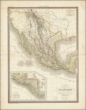
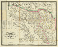
One of the best large format maps of Mexico, Texas and Upper California to appear in a commercial atlas in the 1830s. Texas is clearly delineated in it Republic format, with dozens of place names shown, a well as the road from Natchtoches to the Loredo area. Substantial detail throughout the Rocky Mountains, incorporating Humboldt, Pike and Long. The west reflects the cartography which predates Fremont's explorations, including two Salt Lakes and the mythical rivers which connect them to the Pacific. Lots of Indian Tribes and place names throughout. This 1838 Lapie rarely appears on the market. The browning to the image is the norm, as it was typically washed with a finish after printing, for reasons which are unknown. We have had the map 3 times in 11 years, always with the toning on the map. An excellent Republic and Southwest map.
![[ Texas - Geology ] Erforschung von Nordwest-Texas durch D. O. Lowe & A.R. Roessler 1872 (with) Orientirungskarte . . . 1873](https://storage.googleapis.com/raremaps/img/small/96578.jpg)