|
||

|

|
|

|
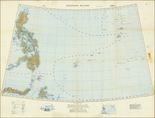
Detailed invasion map of Iwo Jima prepared by the U.S. military in the planning phase for the Battle of Iwo Jima.
There is technically a second sheet to the map (not present here), but as it showed only ocean and a few uninhabited rocks, it is almost never seen.
The legend includes numerous strategically important landmarks:
- Coastal Defense Gun
- Dual Mount Dual Purpose Gun
- Dual Purpose Gun Position (Empty)
- Single Mount Heavy AA
- Automatic AA
- Covered Artillery Emplacement
- Range Finder
- Unidentified Installation
- R.D.F.
- Rifle Pit or Fox Hole
- Mast or Tower
- Underground Entrance
- Air Raid Shelter
- Anti-Tank Gun
- Water Storage
- Machine Gun
- Blockhouse
- Pillbox
- Radar
- Searchlight
- Command Post
- Observation Tower
- Anti-Tank Barrier
- Radio Station
- Radio Tower
- Anti-Boat Barrier
- Open Artillery Emplacement
- Anti-Tank Trench
- Empty Revetment
- Ammunition Storage
- Fire Trench
- Short Sections of Anti-Tank Trench
- Barbed Wire
- Earth Covered Structure
- "Dotted Symbols Indicate Possible Installations".
Iwo Jima, whose name translates as "Sulfur Island", was an important midway point between South Pacific bomber bases that were already in the hands of the Allies and the Japanese home islands. 700 miles from Tokyo and 350 from the nearest U.S. airbase, with a central plain suitable for building large runways, American planners viewed it as a valuable target. The battle for the island was among the bloodiest of the Pacific Theater of the Second World War. In total, 6,800 U.S. Marines lost their lives and 26,000 were wounded, while a staggering 18,000 Japanese defenders died.
![(Second World War - Berghof) Karte des Berghofgeländes Map of the Berghof-area [with:] Karte des Berghofbunkers Map of the Berghofbunker](https://storage.googleapis.com/raremaps/img/small/100680.jpg)
![(Second World War - Postwar Reconstruction) [Archive of Materials Related to American Reconstruction Efforts in Bavaria]](https://storage.googleapis.com/raremaps/img/small/88055.jpg)