


|
||

|

|
|

|
Informing Prospective German Immigrants in the Early 18th Century
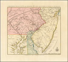
Nice example of JB Homann's map of the British Colonies in Virginia, Maryland, the Carolinas, southern New York and Pennsylvania and New Jersey, a time of considerable immigrant interest among the German speaking parts of Europe.
The map's cartouche speaks to the rich prospects for immigration, with images of friendly prosperous Native Americans and robust commerce, fishing and farming opportunities.
Homann's map was published at a period at the beginning of the 18th Century where the German public was increasingly interested in the British Colonies in North America. In the last quarter of the 18th Century, the first significant group of Germans came to the colonies, mostly settling in Pennsylvania and New York. In 1709, there was a large wave of immigration from the Palatinate region of Germany. Soon thereafter, a number of different groups of Germans arrived in the Southeast and settled in Virginia, North Carolina and Georgia, with others settling in New England. Majority of these settlers were small German-speaking religious groups, including Swiss Mennonites, Baptist Dunkers, Schwenkfelders, Moravians, Amish, and Waldensians; most German immigrants belonged to the main Lutheran and Reformed churches. The middle colonies received the greatest part of this immigration. As many as half of these immigrants came as redemptioners, who agreed to work in America for four to seven years in exchange for free passage across the Atlantic.
Homann's map is one of the most decorative maps of the area, intended to promote German immigration to America. Germantown Teutsche Statt is placed at the headwaters of the Rappahannock. A number of early counties shown in the Carolinas. Nice detail in the interior of Virginia and Maryland for the period. New Jersey is divided into East and West New Jersey.
The region in the west is Florida, extending to a curiously shaped and oversized Lake Erie.
Shows Indian tribes and place names, rivers, bays, coastal soundings, early settlements and other details.
Embellished by one of the most decorative cartouches to appear on a map of the region, showing figures from regional history and local trade with the English. The Atlantic is Mare Virgini [or] Sea of Virginy.
Johann Baptist Homann (1663-1724) was a mapmaker who founded the famous Homann Heirs publishing company. He lived his entire life in Bavaria, particularly in Nuremberg. Initially, Johann trained to become a priest before converting to Protestantism and working as a notary.
In 1702, Johann founded a publishing house that specialized in engravings. The firm flourished, becoming the leading map publisher in Germany and an important entity in the European map market. In 1715, Johann was named Imperial Geographer to the Holy Roman Empire by Charles VI and made a member of the Prussian Academy of Sciences. Most importantly for his business, his reputation and contacts gained him imperial printing privileges which protected his publications and recommended him to customers. Johann is best known for this Grosser Atlas ueber die ganze Welt, or the Grand Atlas of the World, published in 1716.
After Johann died in 1724, the business passed to his son, Christoph (1703-1730). Upon Christoph’s early death, the company passed to subsequent heirs, with the name of the company changing to Homann Erben, or Homann Heirs. The firm continued in business until 1848.


![[Jefferson's Notes on the State of Virginia] Observations sur la Virginie [with the map:] A Map of the country between Albemarle Sound, and Lake Erie, comprehending the whole of Virginia, Maryland, Delaware, and Pensylvania, with parts of several other of the United States of America. Engraved for the Notes on Virginia.](https://storage.googleapis.com/raremaps/img/small/51828.jpg)