|
||

|

|
|

|
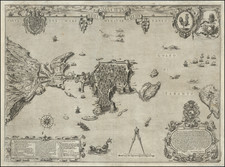
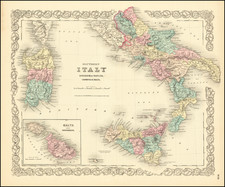
Very rare English chart of southern Italian ports, by Andrew Elton, in superb contemporary hand-color.
Engraved sea chart of the southern Italian ports of Gallipoli (Apulia), Lipari, and Melazzo, with integral town plans. The chart, by Andrew Elton, includes a dedication to Chamberiain (sic) Godfrey.
In 1730 and 1731, the English merchant mariner, Captain Andrew Elton Jr. issued a series of sea charts of harbors and coastal locations that he had visited during his voyages to the Mediterranean Sea. Each chart was masterfully engraved by Bishop Roberts, an artist who subsequently emigrated to American, where he produced one of the most important early views of Charleston, SC.
The British Library dates the chart to 1780, though this is about 50 years too late.
Gallipoli is a fortified port in southern Apulia. It was unsuccessfully besieged by the Venetians in 1484, and since then had been an important harbor in Spanish-controlled southern Italy. Elton wrote that:
Gallipoli, or Callipolis, is seated on a Rock on the Gulph of Tarento, & though it be small it is a very strong & well inhabited Place, being surrounded by y.e Sea except at one place where it is joyn'd to y.e Land by a Bridge defended by a Fort or Castle. It is 25 Miles distant from Otranto, to the West. 36 from Tarento to the South East, & 24 from the Promontory called Capo di S. Maracado di Luca, & is an Episcopal See under the Archbishop of Otranto, but the Bounds of y.e Diocess reach no further than y.e City. The Harbour is said to have been choak'd up by y.e Venetians in y.e 16.th Century [referring to the 1484 Venetian siege, albit with incorrect dating].
Lipari is a harbor on the Aeolian island of the same name that formerly featured a very active volcano. Located near the northern mouth of the Strait of Messina, it lied along a major shipping route and was thus a crossroads of historical events. Elton notes that:
Lipari is the largest of all the Æolian or Vulcanian Islands, being 18 Miles in Compass. It is about 40 Miles distant from the North Coast of Sicily and 50 from the nearest part of the further Calabria. This Island formerly vomited out Fire, as may still be seen by the Marks thereof. There is a Town in it of y.e same Name, which was almost destroy'd by Barbarossa the Turkish Admiral in the Year 1544, but it was afterwards repaired and is now a well inhabited place, with a strong Fort called la Pignatara. Pope Eugenius III, erected it into a Bishoprick, in the Year 1151. Since the Year 1627, it has been exempted from the Jurisdiction of the Archbishop of Messina, till of late that it owns its Subjection to that Metropolitan.
Finally, this fine chart features the harbor of Melazzo, Sicily, which is strategically located near the Strait of Messina. In Homer's Odyssey, Milazzo, known in ancient times as Mylae, was the place where Ulysses was shipwrecked met Polyphemus. Elton notes that:
Melazzo, seated on a Bay 18 Miles North West of Messina, is a strong Large Town with a good Road y.e Germans held it out in 1719 against the Spaniards and forc'd them to retire from before it.
The battle Elton is referring to was the Battle of Milazzo (October 15, 1718), during which an Austrian force under the Count von Daun successfully held the town against a larger Spanish force under the Marquis de Lede.
Rarity
We are aware of only two institutional holdings of Elton charts. The British Library holds examples of the sheets containing the charts of Corve & Zea; Livorno; Charella & Stromboli; Salonica; Naples; and Gallipoli, Lipari & Milazzo. The Richard M. Daly Library at the University of Illinois-Chicago holds the charts of Corve & Zea; Livorno; Charella & Stromboli; Salonica, Gallipoli, Lipari & Milazzo and Smyrna.
Andrew Elton, Junior (fl. 1715-42) was an English merchant mariner who specialized in trade between Britain and Italy and the Ottoman Empire. While clearly a successful businessman and gentleman of prominence, much of his biography remains a mystery. He was the son of Captain Andrew Elton, Senior (1647-1710), a privateer originally from Rotherhithe, Surrey (now in London). Elton Senior was given royal letters of marque, and primarily prayed on French ships in Newfoundland and the English Channel. He was captain of the Russell Galley from the 1695 until 1703, and then the Godfrey Galley until his death, which occurred off of Land's End while he was attempting to take a French ship.
Andrew Elton, Junior, inherited £150 from his father, and eventually the captaincy of the Godfrey Galley. As purchasing, maintaining and crewing such a vessel was extremely expensive, mariners such as Elton usually relied on investors to finance their endeavors, in return for a share of some of the expedition's profits. These inventors tended to be highly prominent figures, such as directors of charted trading companies and politicians, several of which are the named dedicates of Elton's charts. Unlike his father, who largely relied on privateering, Andrew Junior was principally concerned with mercantile trade. The first definitive reference to him concerns his donation of £15 towards the construction of the Parish Church of St. Mary's, Rotherhithe, which was completed in 1715 (E.J. Beck, Memorials to Serve for a History of the Parish of St. Mary, Rotherhithe, London, 1907, p.156).
Andrew Elton Junior was based in Deal, Kent for most of his career, and was known to be captain of at least four different ships. He was associated with the Levant Company (also called the Turkey Company), a royal chartered private syndicate that had held a monopoly on the English trade with the Ottoman Empire since 1580s. He also traded heavily with the port of Livorno (Leghorn), a key entrepot for goods from throughout the Mediterranean.
The first reference to Captain Elton Junior's maritime activities appears in The Post Boy, April 18, 1719, which notes that "Godfrey Galley, Capt. Elton" arrived into Deal "from Leghorn". From that point onwards until 1742, various newspaper announcements record Elton's visits to Livorno (numerous), Messina, Naples, Smyrna, Iskenderun and Alexandria. From 1719 to 1726, he was captain of the Godfrey Galley (and briefly in 1726 the Caesar Galley), while from 1726 to 1731 he was skipper of the Hadley Galley and then the Nile Galley from 1731 onwards. The latest definitive reference to Elton notes that he was an 'Annual Governor' (i.e. Benefactor) of the London Infirmary in 1742 (I. Maddox, The Duty and Advantages of Encouraging Public Infirmaries, London, 1743, p.34).
The engraver of Elton's charts , Bishop Roberts (d.1739), is best known for his historically important view of Charlestown, South Carolina. Roberts was evidently a highly-skilled engraver who seems to have specialized in heraldic devices, as evidenced by the fine arms and cartouches on Elton's charts. In 1728-9 he is recorded as working in London, having the engraver Henry Copeland as his apprentice. By 1733, he appears in New Jersey, where he fulfilled an engraving commission, and by 1735 he had moved to Charleston, South Carolina. Around 1738, he drafted a view of Charleston that is today considered to be one of the most important early records of the city. This view was subsequently published as An Exact Prospect of Charlestown, the Metropolis of the Province of South Carolina, in the London Magazine (1762).
![[ Ostia - Ancient Port of Rome ] Claudii Et Traiani Impp Admirabilium Portuum Ostiensium Orthographia Per Stephanum Du Perach Architectum Iuxta Antiqua Vestigia Accuratissime Delineata . . . 1575](https://storage.googleapis.com/raremaps/img/small/102612.jpg)