


|
||

|

|
|

|
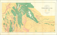
Promoting Irrigated Farm Lands in Southern Idaho
Fine view showing a section of the Snake River from the south, centered on the lower Salmon River and the lands of the Twin Falls North Side Tract and Twin Falls South Side Tract, published in 1908.
The map illustrates the Main Canal for the Salmon River Tract and the Twin Falls High Line Canal, along with the Power Lines and railroad lines connecting the cities in the region. Extends from Boise, Nampa and Fayette at the top left to Yellowstone Park at the top right, with the Great Salt Lake and Ogden at the bottom right and the line of the Southern Pacific, tracking the Idaho-Nevada Border across the bottom of the map.
Includes a Plate of the Twin Falls Country of Southern Idaho on the verso, illustrating the lands of the Twin Falls North Side Water Company, with an extensive text track describing the project, the Carey Act, Twin Falls Salmon Tract, Cheap Electric Power and farming opportunities.
![[ Western United States -- Massive Idaho Territory ]](https://storage.googleapis.com/raremaps/img/small/99057.jpg)
![Map of the United States And Territories, Together with Canada &c. [Shows Massive Idaho Territory]](https://storage.googleapis.com/raremaps/img/small/100353.jpg)