|
||

|

|
|

|
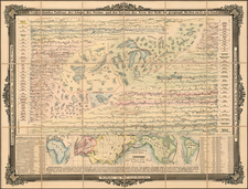
Rare World Map Showing the Ocean Currents—An Early Thematic Map
Rare example of one of the first maps of the world’s ocean currents by German polymath Eberhard Werner Happel. The map also shows volcanic activity and is an early example of thematic mapping.
The present map, whose title translates to “The ebb and flow presented on a flat map,” is a cylindrical projection of the world, with the Americas to the west, Asia to the east, the southern part of Greenland to the north, and Süd-Land (presumably Antarctica) to the south.
As indicated by the map’s title, the illustration of the “ebb and flow” of the world’s oceans is immediately apparent. Happel fills bodies of water on the map with mesmerizing patterns of curved lines, some culminating in whirlpool-like swirls. Darker bands indicate currents. Dotted lines in four areas indicate supposed subterranean tunnels connecting the Black and Caspian Seas, the Caspian Sea with the Persian Gulf, the Mediterranean with the Red Sea, and the Atlantic with the Pacific. The small circles surrounded by another circle of short lines indicate whirlpools where water is sucked down into the subterranean system.
Rivers and mountain ranges are shown on each continent. Active volcanoes are drawn with flames at their tops, both on land masses and in oceans. The Great Wall of China is also drawn in. While some land masses, such as Western Europe and Africa, are depicted relatively accurately, other areas look strange to the modern eye. Especially notable is the great westward distortion of North America, with the northwestern area labeled “California” extending off the left side of the map. Additionally, present-day Russia is prematurely severed on its eastern coast and a large peninsula labeled Nova Zembla hangs over it to the north (corresponding to the present-day archipelago Novaya Zemlya).
Several decorative elements are included. At the center is a compass rose, ornamented on its northern side. A cartouche decorated with plants and flowers appears in the lower left of the map, over which reclines a cherub. The cartouche and its ornamentation are superimposed over another land mass, part of the massive southern continent that runs the length of the projection.
The present map first appeared in Happel’s most famous scientific work, Gröste Denkwürdigkeiten der Welt: Oder, So genannte “relationes curiosae”. Relationes Curiousae, published in 1675, contained one of the most important early discussions of oceanographic phenomena. It also appeared in Happel’s Mundus Mirabilis, published in 1687.
Many of the theories in this map are derived from Athanasius Kircher’s important 1665 map of ocean currents. Kircher, a German Jesuit polymath, theorized that there was a worldwide underground network of canals and caverns through which water flowed. This network connected to counterparts on the surface, such as rivers. Kircher’s map was published in Mundus Subterraneus, his study of the world’s ocean currents, tides, volcanic distribution, and core structure. Happel’s world map is derivative of Kircher’s, but its ocean currents are drawn in more detail and its geography is distinct.
Early Study of Tides and Ocean Currents
The theory of ocean currents depicted in Happel’s and Kircher’s maps is just one of many theories proposed to explain tides and ocean currents beginning in the time of ancient Greece. Since the Mediterranean Sea is almost completely enclosed, its tides are very limited, so it was not until longer journeys were undertaken that the phenomenon began to be studied by Europeans.
Around 330 BC, the Greek astronomer and explorer Pytheas traveled from the western Mediterranean Sea to the British Isles, where he observed ocean tides, and concluded that they were in some way controlled by the Moon. Around 150 BC, the astronomer Seleukos found that the two tides per day had unequal amplitudes when the Moon was far from the equator, a phenomenon known as diurnal inequality. Around the same time, the Greek scientist Poseidonius wrote about the connection of the Moon’s phases to the tides.
Later, at the beginning of the eighth century, the English monk Bede the Venerable discovered that each port in England had its own tidal phase, a phenomenon known as phase lag. Bede believed that the tide ebbed from the Moon blowing on the water, and that it flowed again when the Moon moved. In the mid-thirteenth century, the first scientific attempt to explain tides came from the Persian scientist Zakariya al-Qazwini, who claimed that the flowing tide was caused by the Sun and Moon heating the waters, making them expand.
In the early seventeenth century, German astronomer Johannes Kepler claimed that the tides depended on the attractive force of both the Moon and the Sun, related in some way to magnetism. Italian physicist and astronomer Galileo Galilei, supporting Copernicus’ theory of a rotating Earth, believed the tides were produced by a combined effect of Earth’s rotation around its axis and its orbit around the Sun—these motions caused the oscillation of Earth’s waters, observed as tides.
Various alternate theories appeared in the seventeenth century, mostly from Roman Catholic philosophers, who after Galileo’s condemnation were forbidden to engage with Copernican ideas. As discussed above, Athanasius Kircher believed that, as the Sun traveled over the sea, its heat evaporated water, which created a depression in the water’s surface, leading currents to flow in from either side to restore the water’s level. He also believed winds and tides could cause currents. Kircher’s 1665 map of ocean currents, from which this map is derived, was one of the earliest thematic maps, showing ocean currents and volcanic phenomena.
Isaac Vos, a Dutch scholar who settled in England, agreed that the Sun’s heat created ocean currents, expanding waters so the sea level rose slightly as the Sun moved across it. French mathematician René Descartes believed that the Moon and the Earth were each surrounded by a large vortex, and the pressure exerted by the Moon’s vortex on the Earth’s vortex transmitted down to Earth’s surface, creating tides. In the mid-seventeenth century, English mathematician John Wallis suggested that tidal oscillations resulted from the Earth’s rotation combined with its orbit around the Sun, as well as its motion around the center of gravity of the Earth-Moon system.
Finally, in 1687, the year the present map was published, English mathematician, physicist, and astronomer Isaac Newton published his theory of gravitation, which was key to explaining the phenomenon of tides. According to this theory, the origin of tides was the attractive force of the Moon and Sun and all other celestial bodies—gravitation. The tides were created by different gravitation at different distances from the celestial body. With this theory, Newton was able to calculate the tidal forces of both the Sun and Moon. He was also able to explain the three fundamental properties of tides: their main period of twelve lunar hours; the dependence of amplitude on lunar phases; and diurnal inequality. These theories continued to be clarified and expanded upon in the next centuries.
Early Cartographic Depictions of Tides and Ocean Currents
Aside from the present map by Happel and the Kircher map from which it is derived, there are several other maps from this era that depict tides or ocean currents:
Jodocus Hondius’1624 map Nova Universi Terrarum Orbis Mappa Ex Optimis Quibusque Geographicis Hydrographicisq… notes the ocean currents and magnetic bearings at various points.
Johann Zahn’s 1696 map Tabula Geographico-Hydrographica Motus Oceani Currentes, Abyssos, Montes Ignivomos In Universo Orbe Indicans… is derived from Happel’s and Kircher’s earlier maps, and depicts ocean currents in the same way.
Nicolas Fer’s 1700 map Mappe-Monde, ou Carte Generale de la Terre… includes corner vignettes of tempests and tides.
Adam Friedrich Zürner’s c. 1700 map Planisphaerium Terrestre Cum Utroque Coelesti Hemisphaerio, Sive Diversa Orbis Terraquei… includes a panorama of tempests, earthquakes, vortices, and tides, along with textual commentary on these phenomena.
Rarity
This map appears to be extremely rare. OCLC only lists three institutional examples of the 1687 version, at Princeton, the British Library, and the Bayerische Staatsbibliothek. This is the first time we have had the map in our collection.
Eberhard Werner Happel (1647–1690) was a German author of scientific and historical works. The son of a reformist Lutheran minister, he studied law, mathematics, and natural sciences in Marburg, Germany, from the 1660s to 1680s, though due to financial issues he never finished his formal education. He also tutored aristocratic families in Hessen and Hamburg during this time. Around 1680 he devoted himself to writing, publishing several works of historical fiction. He also published several historical and scientific almanacs, the most famous of which was Historia Moderna Europae, which covered recent European political history and included detailed maps and engravings. His most famous scientific work was Gröste Denkwürdigkeiten der Welt: Oder, So genannte “relationes curiosae”, which contained one of the most important early discussions of oceanographic phenomena. In later years Happel continued to be a successful and widely read author. He died in Hamburg at age 42, survived by his wife, Margarita, and four children.
![[World Map / Malaria / Dr. Seuss ] This is Ann . . . She drinks blood!](https://storage.googleapis.com/raremaps/img/small/73499.jpg)
![[Grateful Dead Tour Poster] The Original Grateful Dead Wall Map & Tour Guide Volume 1 / The Golden Road To Unlimited Devotion](https://storage.googleapis.com/raremaps/img/small/85630.jpg)
![[All The Way With LBJ - 1964 Presidential Election Campaign Poster] Johnson Humphrey for the USA](https://storage.googleapis.com/raremaps/img/small/88907.jpg)