|
||

|

|
|

|
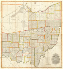
Scarce early map of the Northeastern United States. Includes an early appearance of Michigan Territory, with excellent detail. Also the topographical details in the map are superb, evidencing an early example of what would become the trademark of 19th Century German maps. The map appeared in a very early example of Steiler's Hand-Atlas, one of the most prolific works of the 19th and 20th Centuries. Includes Indian Tribes, canals, and a host of other details. Extends A nice example of a scarce map. from the Chesapeake to Maine and from Lake Michigan to Kentucky. A nice example of a scarce map.
Christian Gottlieb Reichard (1758-1837) was a German cartographer. Reichard studied law in Leipzig and found work as a town clerk in Bad Lobenstein. He had great personal interest in geography, history, and cartography, hobbies which gained him more renown than law. However, even after he began making maps, he continued working his clerk job, which gave him the financial stability to support his family.
Reichard is best known for his work on his Atlas des Ganzen Erdkreises in der Central Projection (Atlas of the Whole World in the Central Projection) in 1803 and the Orbis terrarum antiquus (Atlas of the Ancient World) of 1824. He is also likely the first published cartographer to adopt the Albers conic projection, in his map Die Vereinigten Staaten von Nord-America, nach den sichersten Bestimmungen, neuesten Nachrichten und Charten, in der Alber’schen Projection entworfen, (The United States of North America, after the safest regulations, latest news and charts, designed in the Alberian projection), where he references the Albers projection by name.
Reichard’s work was known by his contemporaries as highly accurate, and in fact this descriptor still holds up today. This accuracy, along with his skill, made him very publishable, and he worked on a number of atlases with other cartographers, such as Steiler’s Handatlas. Reichard’s style is simple but includes great detail, making his maps both recognizable at a glance and engaging upon deeper study.

![Factors of Prosperity in the Rock Island-Frisco States of America [cover title]](https://storage.googleapis.com/raremaps/img/small/94604.jpg)
![[ Temperance Allegorical View ] Black Valley Railroad. Tickets Sold at all Liquor Shops. Accidents by Collisions are Entirely Avoided, as no up Trains are Run Over the Road.](https://storage.googleapis.com/raremaps/img/small/101469.jpg)