


|
||

|

|
|

|
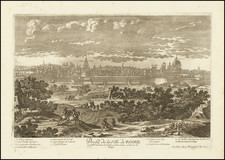
Rome at the Time of Augustus Caesar -- The Pinnacle of the Cartographic Work of Italian Renaissance Architect Pirro Ligorio
Later state of Michael Tramezini's monumental map of the monuments of Rome, first published in 1561.
The map is based upon the work of Italian Renaissance architect Pirro Ligorio, showing Rome as it appeared during the reign of Augustus Caesar (27 BC to 14 AD).
The map shows ancient Rome at a very large scale, allowing the reader to examine the ancient monuments of Rome, as Ligorio himself was then studying and compiling his archive of information about Roman antiquities. It constitutes the first large scale attempt to re-create Rome as it existed during the time of Augustus and at the time of the birth of Christ. Ligorio's work meticulously recreates ancient Rome, with bridges, large public spaces and hundreds of buildings illustrated and many named.
Of note is the simplicity of the area of the future home of the Vatican opposite Porta Aurelia, pre-dating the arrival the Constantinian basilica in 326 AD.
As noted in the title, this is a later issue of the Tramezini plan by Carlo Losi, printed from the original copper plates.
Pirro Ligorio
Pirro Ligorio (1512/13 - 1583) was an Italian architect, painter, antiquarian, and garden designer during the Renaissance period. He worked as the Vatican’s Papal Architect under Popes Paul IV and Pius IV, designed the fountains at Villa d’Este at Tivoli for Cardinal Ippolito II d’Este, and served as the Ducal Antiquary in Ferrara.
Ligorio is known for his passion for classical Roman antiquity. By the mid-16th Century, he began to explore the subject. He spent a large portion of the 1540s learning as much as possible about Roman antiques, preserving valuable information while the pope destroyed artifacts in excavation projects. In the following decade, Ligorio published one book, Delle antichità di Roma in 1553, and also engraved several images.
Ligorio’s period of archeological exploration and writing was accompanied by another pursuit: cartography. Between 1557-1563, Ligorio combined his antiquarian knowledge and drawing abilities to create several maps of Rome. Most notably, in 1561 he published his “Antiquae urbis imago” (Image of Ancient Rome), a topographical map of ancient Rome. This was considered the pinnacle of his cartographical endeavors.
Rarity
The map is rare on the market. We locate 2 examples at auction in the past 30 years and one entry in a dealer catalog (Douwma, 1985).
![Veduta del Prospetto Principale della Colonna Antonina. [A Frontal View of the Column of Marcus Aurelius.]](https://storage.googleapis.com/raremaps/img/small/101718.jpg)
![(Rome) Il Prospetto della Città Leonina, che si vede colla Basilica Vaticana, Ponte, e Castel S. Angelo [The View of the Leonine City, with the Vatican Basilica, Bridge, and Castel Sant'Angelo]](https://storage.googleapis.com/raremaps/img/small/93193.jpg)
![[Spanish Siege of Ostia] Il Vero Disegno Del Sito Di Hostia e Di Porto Con Li Forti Fatti Dal Campo Di Sua Santita et Delli Imperiali Qualisi Resero Adi XXIIII Genaro M. D. L V II . . . .](https://storage.googleapis.com/raremaps/img/small/75401.jpg)
![[Rome] Der Statt Rom in aller Welt . . .](https://storage.googleapis.com/raremaps/img/small/90175.jpg)
![[The Road to Ancient Rome] Waarschynlyke Verbeelding Der Gedaante van den Roomschen Heirweg Buiten de Stad en der Naburige Wegen en Plaatzen aan Dien Gehecht.](https://storage.googleapis.com/raremaps/img/small/88317.jpg)