|
||

|

|
|

|
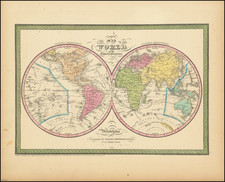
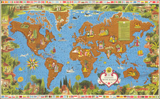
Blaeu's Important and Decorative Double-Hemisphere World Map.
Finely colored example of Johannes Blaeu's scarce double hemisphere map of the World, originally prepared by Joan Blaeu for his Atlas Maior in 1662. The map was also included in contemporary composite sea atlases of the period, by Goos and others.
Unlike Blaeu's first world map which appeared in the majority of his atlases and was done on the Mercator projection, here Blaeu utilizes a double hemisphere format and depicts California as an island.
This double hemisphere map was prepared at the end of the firm's publishing history and is much rarer than its rectangular predecessor. The engraving, layout, and elegance of decoration are all of the highest standard. The map depicts celestial figures seated among the clouds and representations of the four season below, with each figure seated in a chariot drawn by beasts and birds. Because of the relative scarcity of this map and Blaeu's prominence as one of the most influential and decorative map makers of the Golden Age of Dutch Cartography, this map has become especially sought after by collectors and increasingly scarce on the market.
Recently, a variant plate of the Blaeu double-hemisphere map has been discovered, the present example is the standard atlas version. The sea atlas variant can be distinguished by the following characteristics: It includes two sailing ships off the west coast of South America and one ship off the southeastern coastline of South America. The ship below Australia is not present. The three flying fish at the center of the map in the Atlantic are also missing in the variant version of the map. Moreover, a close comparison of the two maps shows many differences, too many to describe, but clearly the result of having been printed with two different plates, not simply revisions to the same plate.
Joan, or Johannes, Blaeu (1596-1673) was the son of Willem Janszoon Blaeu. He inherited his father’s meticulous and striking mapmaking style and continued the Blaeu workshop until it burned in 1672. Initially, Joan trained as a lawyer, but he decided to join his father’s business rather than practice.
After his father’s death in 1638, Joan and his brother, Cornelis, took over their father’s shop and Joan took on his work as hydrographer to the Dutch East India Company. Joan brought out many important works, including Nova et Accuratissima Terrarum Orbis Tabula, a world map to commemorate the Peace of Westphalia which brought news of Abel Tasman’s voyages in the Pacific to the attention of Europe. This map was used as a template for the world map set in the floor of the Amsterdam Town Hall, the Groote Burger-Zaal, in 1655.
Joan also modified and greatly expanded his father’s Atlas novus, first published in 1635. All the while, Joan was honing his own atlas. He published the Atlas maior between 1662 and 1672. It is one of the most sought-after atlases by collectors and institutions today due to the attention to the detail, quality, and beauty of the maps. He is also known for his town plans and wall maps of the continents. Joan’s productivity slammed to a halt in 1672, when a fire completely destroyed his workshop and stock. Joan died a year later and is buried in the Westerkerk in Amsterdam.
![[World -- Terrestrial Globe Gores]](https://storage.googleapis.com/raremaps/img/small/89195.jpg)