This item has been sold, but you can enter your email address to be notified if another example becomes available.


|
||

|

|
|

|
Stock# 62694
Description
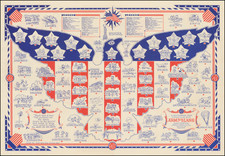
Rare historical / pictorial map of the Mormon Route from Nauvoo to Salt Lake, drawn by Robert A. Hanson.
The map was likely published by the Western Cover Society, a California based society which published the Western Express. Hanson's maps were advertised for sale in this journal as early as 1969.
The map provides an elegant overview route, with daily stops, distances and illustrations of important venues along the route, including:
- Mt. Pisca
- Lone Tree
- Rebecca Winter's Grave
- Chimney Rock
- Ft. Laramie
- Old Ft. Bridger
- Red Bluffs
- Independence Rock
Rarity
The map is now apparently quite rare. We were unable to locate another example.
![Trails: [1595-1945]: Land, Sea, and Air of The American Adventure Series](https://storage.googleapis.com/raremaps/img/small/70672.jpg)