|
||

|

|
|

|
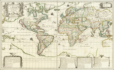
First State of Nicolas Sanson's First Map of the World
First state of Sanson's first map of the World, published by the single most important French mapmaker of the 17th Century, whose modernistic approach to cartography would redefine commercial cartography over the next 50 years and signal the beginning end of Dutch domination of the commercial map trade.
Sanson's double hemisphere map of the world is noteworthy for a number of reasons. It is Sanson's first depiction of the island of California, using a model for the shape of California which would come to be known as the 1st Sanson model. The map also provides a good look at the Great Lakes of North America, a region for which Sanson's regional maps would become the most advanced depictions of the cartography of the region for the next 30 years. The map depicts a curious NW Coast of America, separated from California by an unnamed strait, certainly a curious omission for someone as meticulous as Sanson. This NW Coast would disappear from his subsequent maps.
A very faint outline reflects Sanson's acknowledgement of the prospect of an undiscovered Southern Continent. The depiction of Australia and SE Asia are quite unique. Nice example of this scarce first edition of Sanson's map of the World.
Nicholas Sanson (1600-1667) is considered the father of French cartography in its golden age from the mid-seventeenth century to the mid-eighteenth. Over the course of his career he produced over 300 maps; they are known for their clean style and extensive research. Sanson was largely responsible for beginning the shift of cartographic production and excellence from Amsterdam to Paris in the later-seventeenth century.
Sanson was born in Abbeville in Picardy. He made his first map at age twenty, a wall map of ancient Gaul. Upon moving to Paris, he gained the attention of Cardinal Richelieu, who made an introduction of Sanson to King Louis XIII. This led to Sanson's tutoring of the king and the granting of the title ingenieur-geographe du roi.
His success can be chalked up to his geographic and research skills, but also to his partnership with Pierre Mariette. Early in his career, Sanson worked primarily with the publisher Melchior Tavernier. Mariette purchased Tavernier’s business in 1644. Sanson worked with Mariette until 1657, when the latter died. Mariette’s son, also Pierre, helped to publish the Cartes générales de toutes les parties du monde (1658), Sanson' atlas and the first French world atlas.
![[California, Texas, and Southwest Globe Gore] with [Strait of Anian Globe Gore]](https://storage.googleapis.com/raremaps/img/small/99425.jpg)
![[ World Map ] Карта Шара Земнаго Сочиненная по Астрономическимъ Наблюденїямъ. Жанверомъ. [Globular Map of the Earth Compiled from Astronomical Observations. Janvier]](https://storage.googleapis.com/raremaps/img/small/65900.jpg)