|
||

|

|
|

|
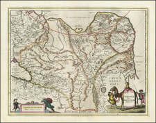
Fine old colored map of Tartary, consisting of the Eastern part of Russia, Central Asia, China and Korea, first published by Nicholas De L'Isle in 1706.
The map extends from the Peninsula of Korea in the east to the Caspian and Black Seas. The Great Wall of China is shown, as is the Silk Route, many roads and remote settlements, mountain ranges, rivers, etc.
The wide swath of the Gobi Desert appears quite prominently, as does the Great Kingdom of Tibet, Cossack regions, the Country of the Mongols and many other features.
De L'Isle was France's leading map maker in the early 18th Century and he and his heirs dominated the French map trade during most of the 18th Century.
Guillaume De L'Isle (1675-1726) is probably the greatest figure in French cartography. Having learned geography from his father Claude, by the age of eight or nine he could draw maps to demonstrate ancient history. He studied mathematics and astronomy under Cassini, from whom he received a superb grounding in scientific cartography—the hallmark of his work. His first atlas was published in ca. 1700. In 1702 he was elected a member of the Academie Royale des Sciences and in 1718 he became Premier Geographe du Roi.
De L'Isle's work was important as marking a transition from the maps of the Dutch school, which were highly decorative and artistically-orientated, to a more scientific approach. He reduced the importance given to the decorative elements in maps, and emphasized the scientific base on which they were constructed. His maps of the newly explored parts of the world reflect the most up-to-date information available and did not contain fanciful detail in the absence of solid information. It can be fairly said that he was truly the father of the modern school of cartography at the commercial level.
De L’Isle also played a prominent part in the recalculation of latitude and longitude, based on the most recent celestial observations. His major contribution was in collating and incorporating this latitudinal and longitudinal information in his maps, setting a new standard of accuracy, quickly followed by many of his contemporaries. Guillaume De L’Isle’s work was widely copied by other mapmakers of the period, including Chatelain, Covens & Mortier, and Albrizzi.
![[ Holy Roman Empire ] Germania del Gastaldo](https://storage.googleapis.com/raremaps/img/small/73754.jpg)