This item has been sold, but you can enter your email address to be notified if another example becomes available.


|
||

|

|
|

|
Stock# 6262
Description
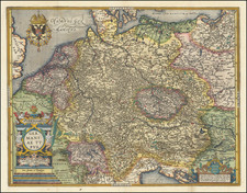
Scarce 17th Century map showing the region bounded by the Baltic, the Oder, the Bug and the Vistula and extending south to Krackow, east to Brierstie Litepski, north to Konigsberg and west to Stetin, Glogau and Breslau. The two unique features of this map are the dozens of heraldic crests which adorn the map and the many roads shown on the map, which was very uncommon during the 17th Century. A nice example of this uncommon map. No appearances in 20 years of the Jolly Price Guide.
![[Napoleon]. A Sketch of the Russian Campaign in 1812](https://storage.googleapis.com/raremaps/img/small/63426.jpg)
![[Daugavgriva] Die Haupt Vestung Dunamunder Schanz Welche die Saxen Anno 1700. Augustusburg nandten, aber Ao. 1701. auff Discretion wider auffgeben miessen.](https://storage.googleapis.com/raremaps/img/small/60087.jpg)