![La Florida [with] Guastecan [with] Peruviae Auriferae Regionis Typus By Abraham Ortelius](https://storage.googleapis.com/raremaps/img/small/84003.jpg)


|
||

|

|
|

|
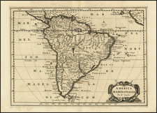
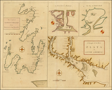
Ortelius’ Map of Florida—The First Separately Printed Map of Florida!
An excellent example of Abraham Ortelius’ seminal map of Florida and the North American South, shown within a trio arrangement of maps focused on Central and South America.
Ortelius’ groundbreaking map La Florida was the foundation for cartography of the region and remained the mapping standard for nearly a century. It is the first separately issued map of the feature. It featured in Ortelius’ Theatrum Orbis Terrarum, the first modern atlas, from its 1584 edition to the 1609 edition.
Along with the highly influential map of Florida, this plate contains a map of the Peruvian region of New Spain, extending from Central America to the Tropic of Capricorn, and a map of an area of central Mexico along the Gulf of Mexico called Guasteca (after the indigenous Huastec people).
Vessels sporting Spanish flags are shown off the western coast of the Americas, clearly delineating the region as Spanish territory. Each map contains fine scrollwork title cartouches; the Guasteca map in particular boasts a fine example topped with a bull and laurel wreath. The cartouche at top right of the Florida map asserts Ortelius’ publishing privilege.
Abraham Ortelius was known for finding map sources few others could access. It was exceptionally rare for popularly printed maps to be based on Spanish sources. However, this fascinating map trio references maps directly from Spanish authors: the map of Peru contains a cartouche citing “Didaco Mendezio”, Diego Mendez, the cartographer for the viceroy of Peru, and the map of Florida cites “Hieron. Chiaves”, Geronimo de Chaves, the Royal Cosmographer to Philip II of Spain and member of the Casa de la Contratación. The Casa de la Contratación was responsible for official Spanish mapmaking of New Spain, and Ortelius’ work is one of the earliest examples of the dissemination of Spanish cartographic information from the New World via the Casa.
These maps are some of the earliest to record internal detail for this region, based upon the findings of Hernando de Soto as recorded by Gonzalo de Oviedo and perhaps other Spanish sources from ca. 1570. Within these maps, cities are marked in bright red. The rivers depicted were particularly accurate for the time and influential for later maps of this region. Viewers will notice a nice example of the Mississippi, or Rio del Spírito Santo, emptying into a bay of the Gulf of Mexico.
Place names from Juan Lopez de Velasco’s famous contemporary work Geografia y descripcion universal de las Indias match those included in Ortelius’ maps, which makes it clear these authors draw from the same primary sources from early Spanish explorations.
As the earliest regional mapping of Florida and the South, Ortelius’ work wielded incredible influence in the history of cartography of the region. This groundbreaking work, accompanied by fine examples of Ortelius’ cartography of New Spain, is an attractive choice for collectors of Florida, the Southeast, Mexico, and the Spanish Empire.
To view a 1.5 minute video description of this map by map collector Thomas Touchton, click here: https://www.youtube.com/watch?v=_D3fapkxRHo
Ortelius's Theatrum Orbis Terrarum (or "Theater of the World") is widely considered to be the first modern atlas, meaning that this was the first published set of uniform maps with supporting text gathered in book form. Previous bound map collections exist, for example the Italian Lafreri atlases, but these were sets of maps selected and bound together on demand. The Theatrum, in contrast, was the best available summary of sixteenth-century cartographic knowledge, covering much of the exploration of the world in the century following the discovery of America.
The atlas was first published in 1570 in Antwerp. Ortelius’ atlas outperformed later competing atlases from other cartographic luminaries like the De Jode and the Mercator families. The broad appeal of the work is demonstrated by the array of languages in which the atlas appeared: in addition to Latin, the atlas was published with text in Dutch, French, German, Italian, Spanish, and English. Between 1570 and 1612, at least 31 editions of the atlas were published in seven languages. The editions grew over time, with the first edition having 70 maps on 53 sheets, and the 1612 edition having 167.
At the time of its publication, the Theatrum was the most expensive book ever produced. Ortelius created all the maps personally, hand drawing the rough sketches. Those drawings were then interpreted into prints by his engravers Frans Hogenberg, Ambrosius Arsenius, and Ferdinand Arsenius.
After Ortelius's death in 1598, the copper plates for his atlas passed to his heirs. They, in turn, sold the collection to Jan Baptist Vrients (1522-1612) in 1601. Vrients added new maps and published the atlas until his own death in 1612. Vrients's widow then sold the plates to the Moretus brothers, who were the successors of Christoffel Plantin. Recent research has unearthed examples of the atlas with maps dated to 1640.
Abraham Ortelius is perhaps the best known and most frequently collected of all sixteenth-century mapmakers. Ortelius started his career as a map colorist. In 1547 he entered the Antwerp guild of St Luke as afsetter van Karten. His early career was as a business man, and most of his journeys before 1560, were for commercial purposes. In 1560, while traveling with Gerard Mercator to Trier, Lorraine, and Poitiers, he seems to have been attracted, largely by Mercator’s influence, towards a career as a scientific geographer. From that point forward, he devoted himself to the compilation of his Theatrum Orbis Terrarum (Theatre of the World), which would become the first modern atlas.
In 1564 he completed his “mappemonde", an eight-sheet map of the world. The only extant copy of this great map is in the library of the University of Basel. Ortelius also published a map of Egypt in 1565, a plan of Brittenburg Castle on the coast of the Netherlands, and a map of Asia, prior to 1570.
On May 20, 1570, Ortelius’ Theatrum Orbis Terrarum first appeared in an edition of 70 maps. By the time of his death in 1598, a total of 25 editions were published including editions in Latin, Italian, German, French, and Dutch. Later editions would also be issued in Spanish and English by Ortelius’ successors, Vrients and Plantin, the former adding a number of maps to the atlas, the final edition of which was issued in 1612. Most of the maps in Ortelius' Theatrum were drawn from the works of a number of other mapmakers from around the world; a list of 87 authors is given by Ortelius himself
In 1573, Ortelius published seventeen supplementary maps under the title of Additamentum Theatri Orbis Terrarum. In 1575 he was appointed geographer to the king of Spain, Philip II, on the recommendation of Arias Montanus, who vouched for his orthodoxy (his family, as early as 1535, had fallen under suspicion of Protestantism). In 1578 he laid the basis of a critical treatment of ancient geography with his Synonymia geographica (issued by the Plantin press at Antwerp and republished as Thesaurus geographicus in 1596). In 1584 he issued his Nomenclator Ptolemaicus, a Parergon (a series of maps illustrating ancient history, sacred and secular). Late in life, he also aided Welser in his edition of the Peutinger Table (1598).
![Qua solennitate Regina a Rege excipiatur [By what ceremony the Queen is received by the King.]](https://storage.googleapis.com/raremaps/img/small/97172.jpg)