|
||

|

|
|

|
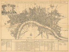
Detailed map of the western half of London, published by Thomas Jefferys in 1735.
The map is the western half of Jefferys New and Exact Plan of the City’s of London and Westminster and the Borough of Southwark And the Additional New Buildings Churches &c to the present Year 1735.
Many of the most important buildings in London are located and illustrated, including:
- Lincoln’s Inn
- Temple
- Covent Garden Market
- Somerset House
- Burlington House
- Soho Square
- Leicester Square
- St. James Square
- Plantation & Admiralty Office
- Scotland Yard
Jeffery's map shows much of the new West End development including:
- Grosvenor Square
- Mount Street
- Cavendish Square.
A nice look at the western half of London during the 1730s.
Thomas Jefferys (ca. 1719-1771) was a prolific map publisher, engraver, and cartographer based in London. His father was a cutler, but Jefferys was apprenticed to Emanuel Bowen, a prominent mapmaker and engraver. He was made free of the Merchant Taylors’ Company in 1744, although two earlier maps bearing his name have been identified.
Jefferys had several collaborators and partners throughout his career. His first atlas, The Small English Atlas, was published with Thomas Kitchin in 1748-9. Later, he worked with Robert Sayer on A General Topography of North America (1768); Sayer also published posthumous collections with Jefferys' contributions including The American Atlas, The North-American Pilot, and The West-India Atlas.
Jefferys was the Geographer to Frederick Prince of Wales and, from 1760, to King George III. Thanks especially to opportunities offered by the Seven Years' War, he is best known today for his maps of North America, and for his central place in the map trade—he not only sold maps commercially, but also imported the latest materials and had ties to several government bodies for whom he produced materials.
Upon his death in 1771, his workshop passed to his partner, William Faden, and his son, Thomas Jr. However, Jefferys had gone bankrupt in 1766 and some of his plates were bought by Robert Sayer (see above). Sayer, who had partnered in the past with Philip Overton (d. 1751), specialized in (re)publishing maps. In 1770, he partnered with John Bennett and many Jefferys maps were republished by the duo.
![[ London - Chelsea ] An Accurate Survey of the Botanic Gardens at Chelsea with the Elevation and Ichnography of the Green House and Stoves, and an Explanation of the Several Parts of the Garden, shewing where the most conspicuous Trees and Plants are Disposed, the Whole Carefully Survey'd and Delineated by John Haynes](https://storage.googleapis.com/raremaps/img/small/85457.jpg)