


|
||

|

|
|

|
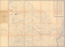
Large map of Calcutta (Kolkata), India, published in that city shorty after India's Independence.
Fine image of the city of Calcutta (Kolkata) as it appeared shortly after India had won her independence (in 1947).
The map is one of the most attractive and detailed general maps of city made during the era. The map is centered upon the great citadel of Fort William (built by the East India Company in the present form in 1756-60). In orange and black (with water in blue), Calcutta appears on the left bank of the Hooghly River, while the industrial suburb of Howrah is located on the right bank.
The city's many colonial buildings, temples, churches, railways stations and palaces are outlined.
The Index Showing Important Places amazingly labels 238 sites of interest, rendering the map s coverage to be exceedingly detailed, while at the same time keeping the image clean and uncluttered.
An inset, in the upper left, References , identifies the symbols used to express Railways, Tramways, Roads, Buildings, Temples, Post Offices, Post & Telegraph Offices, and Police Stations. Further to the left is another inset with a small public transport map of the city, Bus Routes Calcutta & Howrah .
![[Tiruchirappalli] 1763 Plan de Trichenapaly](https://storage.googleapis.com/raremaps/img/small/58955.jpg)
![[ Postal Map of India ] India Shewing The Post Roads And Dawk Stations By James Wyld . . .](https://storage.googleapis.com/raremaps/img/small/99685.jpg)
![[ Dalai Lama ] Grand Lama](https://storage.googleapis.com/raremaps/img/small/97873.jpg)