|
||

|

|
|

|
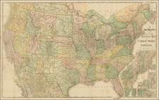
One of the Earliest Maps of The United States After The American Revolution
Rare Covens & Mortier map of the United States, one of the earliest appearances of a representation of an American Flag and one of the earliest maps to name the United States (in both French & Dutch!).
The title cartouche refers to the thirteen United States in both French and Dutch and is decorated by an American flag with thirteen stars. Thus this is one of the earliest maps displaying the stars and stripes. The area mapped is from James Bay to the Gulf of Mexico and from the Atlantic coast to central Texas.
There is a fascinating road running from Port Royal along the coast to Fort George, near Penobscot Bay. Roads are not generally shown on a map of this scale at this time, making that quite unusual. Many towns, rivers and other landmarks are located, as well as Native American tribes and state boundaries, which extend to the Mississippi River.
It has been speculated that Reiner & Joshua Ottens originally made the plate for this map in 1755 under the title "Carte des possessions Angloises & Francoises du continent de l'Amerique Septentrionale". It was then acquired by Covens & Mortier and reworked to show the newly formed states and may have appeared as early as 1783.
Rarity
The map is quite rare, this being the second time we have offered the map for sale.
Johannes Covens (1697-1774) was a Dutch geographic publisher based in Amsterdam. He is best known for his collaboration with fellow publisher Cornelis Mortier (1699-1783). Pierre Mortier the Elder (1661-1711) had obtained a privilege in 1690 to distribute the works of French geographers in the Netherlands. After his widow continued the business for several years, Cornelis took over in 1719.
In 1721, Mortier forged a partnership with Covens, who had recently married Cornelis’ sister. They published under the joint name of Covens & Mortier. In 1774, upon the death of his father, Johannes Covens II (1722-1794) took over his father’s share. In 1778, the company changed its name to J. Covens & Zoon, or J. Covens & son.
Covens II’s son, Cornelis (1764-1825), later inherited the business and brought Petrus Mortier IV back into the fold. Petrus was the great-grandson of Petrus Mortier I. From 1794, the business was called Mortier, Covens & Zoon, or Mortier, Covens, & Son.
The business specialized in publishing French geographers including Deslisle, Jaillot, and Sanson. They also published atlases, for example a 1725 reissue of Frederik de Wit’s Atlas Major and an atlas, with additions, from the works of Guillaume Delisle. There were also Covens & Mortier pocket atlases and town atlases. The company profited from acquiring plates from other geographers as well. For example, the purchased Pieter van der Aa’s plates in 1730. Finally, they also compiled a few maps in house. At their height, they had the largest collection of geographic prints ever assembled in Amsterdam.
Cornelis Mortier (1699-1783) was a Dutch publisher who specialized in geography. Cornelis’ father, Pierre Mortier the Elder (1661-1711), had obtained a privilege in 1690 to distribute the works of French geographers in the Netherlands. After his widow continued the business for several years, Cornelis took over in 1719.
In 1721, Mortier forged a partnership with Johannes Covens, who had recently married Cornelis’ sister. They published under the joint name of Covens & Mortier. Their firm was one of the largest and most successful in Dutch history and continued in business until the late-nineteenth century.
In 1774, upon the death of his father, Johannes Covens II (1722-1794) took over his father’s share. In 1778, the company changed its name to J. Covens & Zoon, or J. Covens & Son. Covens II’s son, Cornelis (1764-1825), later inherited the business and brought Petrus Mortier IV back into the fold. Petrus was the great-grandson of Petrus Mortier I. From 1794, the business was called Mortier, Covens & Zoon, or Mortier, Covens, & Son.
The business specialized in publishing French geographers including Deslisle, Jaillot, and Sanson. They also published atlases, for example a 1725 reissue of Frederik de Wit’s Atlas Major and an atlas, with additions, from the works of Guillaume Delisle. There were also Covens & Mortier pocket atlases and town atlases. The company profited from acquiring plates from other geographers as well. For example, the purchased Pieter van der Aa’s plates in 1730. Finally, they also compiled a few maps in house. At their height, they had the largest collection of geographic prints ever assembled in Amsterdam.
![[ Massive Misplace Idaho Territory ] The United States of North America.](https://storage.googleapis.com/raremaps/img/small/99361.jpg)