The item illustrated and described below is sold, but we
have another example in stock. To view the example which
is currently being offered for sale, click the
"View Details" button below.


|
||

|

|
|

|
Stock# 62398
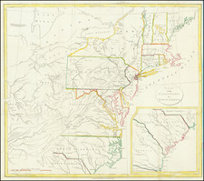
Description
Detailed map of the region, showing counties, towns, rivers, roads, mountains, bridges, lakes, post offices, court houses, and a host of other information.
The Society for the Diffusion of Useful Knowledge was active from the 1830s through the 1860s and published some of the best regional maps of the era. This map relies on the American published maps of Tanner and Gordon.

![[ Southern Railroads ] Railroad Map of the Southern States Shewing the Southern & Southwestern Railway Connections With Philadelphia. 1862 . . . Prepared by Thomas Kimber Jr., Chairman of the Committee on Inland Transportation of the Board of Trade of Philadelphia](https://storage.googleapis.com/raremaps/img/small/103211.jpg)