|
||

|

|
|

|
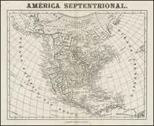
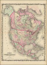
Interesting map of North America, extending to the Arctic Circle. Alaska is Russian America, with its Northern Arctic Coastline still not completely known and its coastline still far from well settled. The West Coast is now being explored, although the map pre-dates the great explorations of the US Exploring Expedition, Duflot Du Mofras and others. Little has changed in the years since Lewis & Clark reached the Pacific, the US having been sidetracked by the War of 1812, among other events. Mexico still controls the region which would become California, Utah, Colorado, Arizona, New Mexico Nevada and Texas, with Steven Austin & Moses Austin's first efforts to colonize Texas still a few years away. The boundary of the US is still the 49th Parallel, with the dispute with Britain for British Columbia still 10+ years in the future. The mythical Rio Buenaventura attaching San Francisco Bay and Salt Lake is still in evidence, although tentatively so, and the mytical second Salt Lake still appears. The Rocky Mountains are shown extending from the Yucatan to the Arctic Sea, little changed from Humboldt's work, and still a single band. While issued in the same year a the Long Expedition to the Rocky Mountains, the discoveries in the Plains are still not in evidence on this map.
![Nord-Amerika [North America]](https://storage.googleapis.com/raremaps/img/small/91328.jpg)