|
||

|

|
|

|
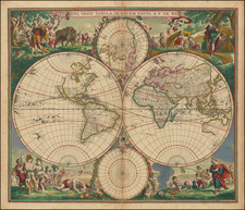
A Cook Rarity Charting James Cook's three voyages through the South Seas and the Pacific
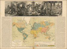
First edition of Faden's extremely rare separately issued map of the World on Mercator's Projection showing the tracks of all three of Cook's voyages as well as the Arctic expedition of Captain Phipps, published by shortly after the completion of Cook's final voyage.
This fine map was issued by William Faden (1749-1836), then Britain's leading cartographer and the official Geographer to King George III. It depicts the world, including the revolutionary re-charting for the Pacific, following the voyages of Captain James Cook (1728-79). Much of the Pacific remained a complete enigma until Cook's three voyages of 1768-71, 1775-6 and 1776-80. The maps features the tracks of Cook's voyages as recorded in his journals and charts which were submitted to the British Admiralty. The coastlines discovered and mapped by Cook are distinguished by pink and bright blue hues of original color. These areas notably include the East Coast of Australia, most of the coastlines of New Zealand, the Hawaiian Islands (discovered by Cook in 1778), much of the coastlines of British Columbia and Southern Alaska, and the Bering Straits and Bering Sea (where Cook attempted to find the Northwest Passage). Cook was killed in Hawaii in 1779, and his party returned to England in 1780. Cook was henceforth celebrated as one of the greatest British heroes of the era, and the foremost explorer of the 18th-century. World maps summarizing all three of his voyages were first issued in 1784, and the present map appeared only a few years later, when the epic nature of his discoveries still dominated scientific and geopolitical discourse.
Lord Mulgave Expedition to the North Pole
The map contains an added bonus to the depiction of Cook's discoveries, being the addition of the tracks of the Arctic expedition of Captain Constantine Phipps (1744-92, later known as the 2nd Baron Mulgrave), conducted in 1773. On June 4, 1773, Phipps's party, aboard the HMS Racehorse and HMS Carcass set out from Deptford. Aboard was the naturalist Israel Lyons and the young midshipman, Horatio Nelson (later Britain's greatest naval hero). The expedition sailed to the Svalbard Islands (now part of Norway), located above the Arctic Circle. Conducting the first scientific evaluations of the islands, they became the first Europeans to describe the Polar Bear and the Ivory Gull. The mission returned in September of that year, whereupon Phipps prepared his work, A Voyage toward the Pole... (1774). Phipps' journals and logbooks are today preserved in the British Library, and are considered important primary sources for early scientific polar studies.
Rarity
The present map is very rare, we are aware of less than a dozen institutional examples, and are aware of an example appearing only once in a dealers' catalog during the last 25 years. While separately-issued, the map was occasionally included in composite atlases (such as with the example at Yale University). The map was subsequently reissued by James Wyld, Faden's successor, in 1828 and 1838, adding the tracks of early 19th-century voyages.
William Faden (1749-1836) was the most prominent London mapmaker and publisher of the late-eighteenth and early-nineteenth centuries. His father, William Mackfaden, was a printer who dropped the first part of his last name due to the Jacobite rising of 1745.
Apprenticed to an engraver in the Clothworkers' Company, he was made free of the Company in August of 1771. He entered into a partnership with the family of Thomas Jeffreys, a prolific and well-respected mapmaker who had recently died in 1771. This partnership lasted until 1776.
Also in 1776, Faden joined the Society of Civil Engineers, which later changed its name to the Smeatonian Society of Civil Engineers. The Smeatonians operated as an elite, yet practical, dining club and his membership led Faden to several engineering publications, including canal plans and plans of other new engineering projects.
Faden's star rose during the American Revolution, when he produced popular maps and atlases focused on the American colonies and the battles that raged within them. In 1783, just as the war ended, Faden inherited his father's estate, allowing him to fully control his business and expand it; in the same year he gained the title "Geographer in Ordinary to his Majesty."
Faden also commanded a large stock of British county maps, which made him attractive as a partner to the Ordnance Survey; he published the first Ordnance map in 1801, a map of Kent. The Admiralty also admired his work and acquired some of his plates which were re-issued as official naval charts.
Faden was renowned for his ingenuity as well as his business acumen. In 1796 he was awarded a gold medal by the Society of Arts. With his brother-in-law, the astronomer and painter John Russell, he created the first extant lunar globe.
After retiring in 1823 the lucrative business passed to James Wyld, a former apprentice. He died in Shepperton in 1826, leaving a large estate.
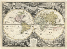
![[Grotto of Tethys -- Versailles] Le Soleil qui se couche dans la mer / Le Globe de la Terre, divise en six parties.](https://storage.googleapis.com/raremaps/img/small/79606.jpg)