
The item illustrated and described below is sold, but we
have another example in stock. To view the example which
is currently being offered for sale, click the
"View Details" button below.


|
||

|

|
|

|
Stock# 62295
Description
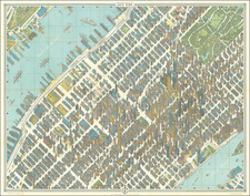
Detailed map of midtown Manhattan to the Flatiron Building, published in New York City by Pictorial Maps Ltd.
A fine detailed pictorial map of midtown Manhattan with the buildings rendered as a bird’s-eye view in isometric perspective.
The map was produced by Hermann Bollmann, who developed his own techniques for pictorial maps of cities.
Created for the 1964 New York World’s Fair, Bollman exhibited a massive version of his map on site. Smaller versions were issued in various formats including in a multilingual guidebook to the city, a separate two-sided folding pocket map for visitors to the World’s Fair.
![[Manhattan / Lower East Side]](https://storage.googleapis.com/raremaps/img/small/59559.jpg)

![[Democratic Republic of the Congo] Congo Belge](https://storage.googleapis.com/raremaps/img/small/77991.jpg)