|
||

|

|
|

|
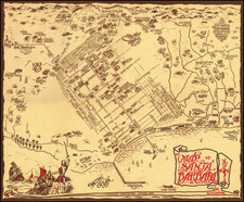
Post San Francisco Earthquake Berkeley Development -- Showing The Proposed State Capitol Building in Berkeley!
Rare birdseye view style promotional map for Berkeley Gardens Tract No. 1 (El Cerrito, California), issued in May 1907 by Schmidt-Skilling Company, General Agents, 2172 Shattuck Ave, in Berkeley.
The promotional pamphlet was issued in May 1907, a year which saw Berkeley's population nearly double, as a result of the exodus from San Francisco following the April 18, 1906 earthquake and fire, which leveled much of the city and left approximately 200,000 residents homeless.
On the verso is a large map of Berkeley Gardens, "reached directly by the San Pablo Avenue Cars," along with a short promotional text tract and illustrations of 3 different home types.
The birdseye view (looking southwest with San Francisco in the background) shows the development tract in green and a modern looking train line running through the center (Santa Fe Rail Road), with the "Key Route" highlighted to the left (east), highlighting Ashbury / Key Route Blvd, with street cars in the middle.
At the top left, above the map title, the Proposed State Capitol, University of California and Claremont Hotel are highlighted, along with Sn. Joseph's Academy (now St. Mary's College High School). In 1903, St. Joseph's (then independent of St. Mary's) was moved from its original location at 30th and Broadway in Oakland to the Peralta Park (as shown on the map), Peralta Park was then a 12.5 acre plot that was part of the original 48,000-acre Spanish land grant of 1820 to Don Luis Maria Peralta. Over the next 50 years, it would grow to house all of St. Mary's College.
California State Capitol in Berkeley?
Berkeley's population almost doubled during the year after the San Francisco fire. Its Chamber of Commerce, which had been organized in 1905, found so much reason to extol the city that it put forward strong claims in 1907 for transfer of the State Capital to Berkeley. The university city had something to offer the State government in the form of a commanding site overlooking the Golden Gate. Also, "the present state capitol building at Sacramento is in a deplorable condition of dilapidation and ruin" declared a Chamber of Commerce resolution.
The legislature approved the move and tons of circulars were distributed throughout the state, but in 1908 the change was defeated by the voters by a margin of about 33,000 votes.
The city named streets around the proposed capitol grounds for California counties. They bear those names today, a legacy of the failed referendum.
Rarity
OCLC and other internet sources locate no other examples of the map.