


|
||

|

|
|

|
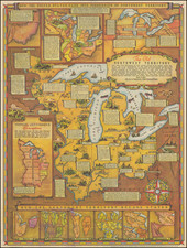
Striking Map of the NW Territory, with inset maps in the middle left, showing Thomas Jefferson's model for creating 15 states along the Meridian of the Falls of Ohio (including the names of 9 proposed states, Sylvania, Michigania, Assenisipia, Ilinois, Polypotania, Cheronessus, Metropotamia, Saratoga and Peilsipia).
Additional insets at the top showing the regional development and at the bottom focusing on the states which are part of the old NW Territory. On the verso is the Text of the Ordinance of 1787, with 5 views showing the legislative progress of the ordinance and modern commentary. A fine example of this map, prepared under the auspices of the WPA. This art was created by Fred Rentschler, who focused on the availability of adult public education and whose work challenged the viewer to assess their ignorances and do something about them. He was one of thousands of artists who participated in the Federal Art Project. Part of the Works Progress Administration, the project started in 1935, it survived until 1943. Numerous notes and illustrations within the body of the map.

![Los Angeles Ambassador [Hotel Ambassador]](https://storage.googleapis.com/raremaps/img/small/97008.jpg)