|
||

|

|
|

|
Rare Riverside, California Promotional Pamphlet with maps and view
Rare 30 page illustrated promotional pamphlet, promoting the Riverside Land and Irrigating Company.
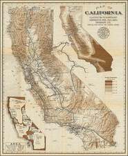
includes a very early view of Riverside, then part of San Bernardino County, a map of California and a map of the lands owned by the Riverside Land and Irrigating Company, which include the townsites for the towns of Alvord, Bayward and Riveside, then part of the Jurupa Rancho.
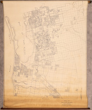
The Riverside area map is of great interest, surveyed & Drawn by Civil Engineers G.C. Miller & G. O. Newman of Riverside. Oriented with northwest at the top, the map follows what is now the route of the 91 and 215 freeweays, following the Santa Ana River from the Mill Property (Grand Terrace) to the San Jacinto Company Tract, just west of Southwest Arlington.
While titled as the Third Edition, there does not seem to be an earlier edition to survive.
Rarity
This is the first time we have ever seen this pamphlet for sale.
OCLC locates 4 copies (Claremont Colleges, UC Berkeley, SMU DeGolyer Library, Huntington Library). OCLC suggests a first edition may have been printed in 1876.
![(Southern California Aerial Photographs) [Collection of 9 Aerial Photographs of San Fernando Valley, Van Nuys, and Burbank]](https://storage.googleapis.com/raremaps/img/small/94783.jpg)