|
||

|

|
|

|
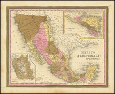
Finely executed map of the United States, Mexico and Canada, showing the Republic of Texas.
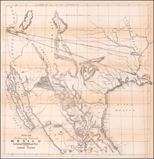
During the 1820s to 1840s, the major French cartographic publishing houses generated some of the most outstanding and historically significant maps of the American west. This map incorporates remarkable details from the early western explorations of Lewis & Clark, Long and others. There is a massive Missouri Territory. Oregon Territory extends to encompass much of British Columbia.
Many fascinating placenames and mythical geological features in the west, including 2 salt lakes, each connected to San Francisco Bay by mythical rivers. Lots of Indians, early forts, and an early location of the Santa Fe Trail, although with an erroneous route.
One of the most interesting atlas maps of the period.

![[Uncut promotional broadsides for ] Map of the Surface-Feeding Ducks, Swans and Geese of North America](https://storage.googleapis.com/raremaps/img/small/92052.jpg)
![[ Early United States Map ] Carte Des Etats-Unis De L'Amerique Septentrionale, dresse d'apres des Cartes Anglaises…](https://storage.googleapis.com/raremaps/img/small/39783.jpg)