|
||

|

|
|

|
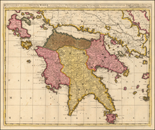
Exceptional old color example of Josua Ottens rare map of Corfu and vicinity, published in Amsterdam.
The map includes large inset maps of the Adriatc Sea and a plan of Corfu and environs, the latter with a table identifying about 30 points of interest.
The map was issued shortly after the Second Ottoman Seige. The second great siege of Corfu (1716) tood place during the last Ottoman–Venetian War (1714–18). After the conquest of the Peloponnese in 1715, the Ottoman fleet appeared in Buthrotum opposite Corfu. On July 8, 1716, the Ottoman fleet, sailed to Corfu from Buthrotum and established a beachhead at Ipsos. The same day, the Venetian fleet encountered the Ottoman fleet off the Corfu Channel and defeated it in the ensuing naval battle. On July 19, after taking a few outlying forts, the Ottoman army reached the hills around the city of Corfu and laid siege.
Despite repeated assaults and heavy fighting, the Ottomans were unable to breach Corful's defenses and were forced to abandon the siege after 22 days. A force of 5,000 Venetians and foreign mercenaries, together with 3,000 Corfiotes, under the leadership of Count von der Schulenburg who commanded the defense of the island, were victorious. The success was owed in no small part to the extensive fortifications, where Venetian castle engineering had proven itself once again against considerable odds.
The repulse of the Ottomans was widely celebrated in Europe, Corfu being seen as a bastion of Western civilization against the Ottoman tide.
Rarity
The map is very rare on the market. We have not located any examples at auction or in dealer catalogs.
![[Greece] Tabula Europae X](https://storage.googleapis.com/raremaps/img/small/86695.jpg)
![[ Siege of Corfu ] Plan du Siege de Corfu par Terre et par Mer avec la situation de deux Flottes Venitienne et Ottomanne depuis le jour de L'entree de celles des Ottomans dans le canal le 5me de Iuillet jusqu an 2 6me d'aout 1716, Iour de sa retraite.](https://storage.googleapis.com/raremaps/img/small/84818.jpg)