The item illustrated and described below is sold, but we
have another example in stock. To view the example which
is currently being offered for sale, click the
"View Details" button below.


|
||

|

|
|

|
Stock# 61953
Description
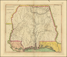
The earliest obtainable large map of Mississippi Territory
Fine example of this important early map of Mississippi Territory, from the 1814 edition of Matthew Carey's General Atlas.
The map pre-dates the creation of Alabama Territory, extending from Georgia to the Mississippi River. Includes a number of early roads, towns, rivers, Indian tribes, settlements, etc. A number of early forts also appear, including Fort McHenry, Fort Stevens, Fort Pickering, etc. Many early Indian villages also named.
Full color examples of this map are very rare on the market.
![[ Mississippi River Atlas ] Theorie der Bewegung des Wassers in Flüssen und Canälen. . . . (Atlas Volume)](https://storage.googleapis.com/raremaps/img/small/101700.jpg)


![(18th-Century Southern Borderlands) [Collection of manuscript letters to Secretary of War James McHenry from confidential U.S. agent John McKee, relating to southern borderlands, Native Americans and Panton, Leslie & Co.; a letter from John McKee written from Mobile, Alabama, to William Blount of Blount's Conspiracy fame; a letter from William Panton concerning John McKee; and letters from Felix D. St. Hilaire, concerning General Victor Collot]](https://storage.googleapis.com/raremaps/img/small/90005.jpg)