|
||

|

|
|

|
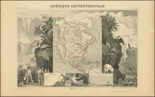
Deluxe edition of Brion De La Tour's map of the American Southwest, etc, exhibiting the extent of discoveries in the Southwest, Alaska and the Arctic Regions.
Two long rivers run from California to the Rocky Mountain region, the Northernmost attaching Lake Winnipeg. Extensive note regarding explorations along the Northwest Coast of America, but the Sea of the West has given was to the Decouvertes Des Russes.
The Mississippi River drainage is now well explored by the French, who are now shifting west following the end of the French & Indian War. A number of French forts shown, including Detroit, S. Pierre, S. Charles, S. Phillipe, Huillier, S. Francisco, and Rosalie.
A decorative map from Brion De La Tour, one of the most prolific cartographic publishers of the mid 18th Century. This deluxe edition includes an elaborate decorative border and is on extra thick paper.
Louis Brion de la Tour (ca. 1743-1803) was a French geographer and demographer. Little is known about Louis’ early life, but some glimpses of his professional life survive. He did achieve the title of Ingénieur Géographe du Roi. Much of his work was done in partnership with Louis Charles Desnos, who was bookseller and geographical engineer for globes to the Danish Crown. He worked on the Indicateur fidèle ou guide des voyageurs, qui enseigne toutes les routes royales between 1762 and 1785. During his career he also worked on several atlases. By 1795, he had gained a pension from the National Assembly. Perhaps this pension was granted in part because his son, also Louis Brion de la Tour (1763-1823), was an engraver who made Revolutionary prints, as well as maps.
![[Fruit Crate Label Advertising Map] Panama Brand (North America & Panama Canal)](https://storage.googleapis.com/raremaps/img/small/48860.jpg)