|
||

|

|
|

|
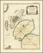
Rare Broadside Showing the Fortifications of Djerba After the Christian Victory in 1560
Rare broadside plan of walled fortifications on Djerba, published shortly after the successful taking of the island by a multi-national Christian force in early 1560. This is an extremely scarce first state of the work, of which there are only two known institutional examples.
The broadside proclaims the victory of Christian forces in taking Djerba in early March 1560. The document was likely printed soon after news of the victory reached Italy. The victory resulted in a short-lived period of Christian control of the island and the strengthening of fortifications around the pre-existing castle, as shown in the image.
The rarity of the broadside may be attributable to the loss of the island to the Ottoman forces two months later, in May 1560. Thus, the proclamation of victory rang hollow and made the broadside far more ephemeral.
The fort itself is shown in the upper-right corner of the sheet. It is Houmt Souk, located in the north of the island. The fort has a series of walls meant to prevent land invasion, and the sea side is left open. An inlet from the sea fills a moat that surrounds the town at the center of the walls, and another moat guards the outer walls as well. Soldiers, some mounted, drill in the inner space between the walls and the town.
The walled city inside the higher, and intimidating, fortress walls is filled with buildings. More soldiers patrol and march in formation. Some guard the corner towers. One building in particular is recognizable as it is topped with a crescent and has two towers—a mosque.
Instead of Djerba, the modern name for the island, the broadside refers to Girba. Girba was the Catholic diocese which included the island. Bishops of Girba were prominent, particularly from the fourth to the sixth centuries, and this historical tie to Christianity is how the European forces justified their aggression.
Djerba
The island of Djerba had a lengthy history of visitors and invaders long before the battles of 1560. The island is mentioned in Homer’s Odyssey, as it is the supposed land of Lotus-Eaters. When Odysseus and his crew became stranded there, his men at the lotus and lost all desire to leave.
A Jewish minority has existed on the island since the sixth century BC and the island houses one of the oldest synagogues in continuous use in the world; El Ghriba has been open for over 2,000 years. The Romans also found Djerba inviting; they were responsible for the thin land bridge that connects the island to the mainland. Djerba appears in the writings of Pliny the Elder and on the Peutinger Table, which has fourth century AD origins.
In the Middle Ages, Islam came to the island, but was contested by Christians from Sicily and Aragon. These disputes produced the island’s distinctive fortified mosques. The Norman Kingdom of Sicily managed to take control of the island twice, for two decades in the twelfth century and for five decades between the thirteenth and fourteenth centuries.
In 1503, Barbary pirates took over the island, giving it over to nominal Ottoman control. Spain, worried about this large pirate base in the western Mediterranean, tried to capture the island in 1510, and again in 1520. This time they were successful, controlling the island for three years. They also had some control of the island in the 1550s.
After the 1560 Battle of Djerba, chronicled in this broadside, Europeans would no longer be able to interfere directly in Djerba affairs. The Ottoman regency of Tunis ruled over the island until 1881, after which it joined the French protectorate.
Battle of Djerba
In the winter of 1559, a multi-national Christian fleet commanded by the Genoese Giovanni Andrea Doria was assembled at Messina. The polities represented included the Maltese, the Papal States, the Genoese, the Neapolitans, and the Spanish. They set sail, with the taking of Tripoli as their goal. They stopped first in Malta, where they stayed for several months. On February 10, 1560, the fleet left for Tripoli. However, many of their crews were sick and weak, forcing their withdrawal to Djerba. They captured the island early in March of 1560.
After the victory, the Viceroy of Sicily, Juan de la Cerda, ordered a fort to be built in the European style. Construction began immediately. While the walls went up, an Ottoman fleet of nearly 100 ships under the command of the Ottoman admiral Piyale Pasha left Istanbul. They arrived at Djerba on May 11, 1560, taking the Christian forces by surprise. After a brief engagement, the Ottomans destroyed much of the Christian forces; the remaining defenders entrenched themselves in the fort. They held out for three months, but eventually had to surrender.
The defeat shocked Europe, particularly Spain, who had lost a sizeable portion of its already too small fleet. The Ottomans, emboldened, set their sights on a larger target, Malta, which they unsuccessfully laid siege to in 1565. The loss at Djerba forced Spain to change tactics and focus on the build-up of its navy, an important development on the road to the greatest European-Ottoman naval engagement, the Battle of Lepanto in 1571.
Rarity and states of the map
This is an extremely rare first state of the map, of which there are only two known institutional examples, both at the Biblioteca Nazionale Centrale di Firenze. This first state is the only one to contain the text about the battle. Later states remove the text, most likely because they were printed after the defeat of the Christian forces; the role of the propaganda text was no longer valid.
The states of the map are as follows:
1st state: this example, with the typographic text.
2nd state: printed sheet without the text.
3rd state: a title is added at the top, “FORTEZZA DI GERBI.”
4th state: address added, “Romae Claudij Duchetti formis.”
5th state: imprint added, “Ioannes Orlandi formis romae 1602.”
The fort, and this broadside, are reminders of a specific skirmish and of the larger wars between Christian Europe and the Ottoman Empire. It would make a fascinating addition to any collection of North African, sixteenth-century maritime, and Mediterranean maps.
![Barbaria [with] Cartaginis sive potius Tunetani celeberrimi Sinus nec non fortalitij . . . [with] [Untitled map of Egypt]](https://storage.googleapis.com/raremaps/img/small/72788.jpg)
![Fezzae et Marocchi Regna Africae Celeberrima, describebat Abrah: Ortelius. [Fez and Morocco, the most famous Kingdoms of Africa, as described by Abraham Ortelius]](https://storage.googleapis.com/raremaps/img/small/94255.jpg)