


|
||

|

|
|

|
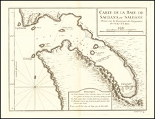
False Bay / Cape Town, South Africa
Rare chart of False Bay, which appeared in the so-called VOC Secret Atlas.
The map shows "Post-huys", the signal blockhouse built as an observation post controlling False Bay and which was completed in 1673, a year before the Castle in Cape Town was occupied.
The chart was made for and used by the VOC (Dutch East India Company) for navigation and trading.
The chart appeared in volume VI (1753) of Johannes II van Keulen's Zee-Fakkel, he so called "secret atlas" of the VOC. For two centuries, from 1602 to 1799, the Dutch East India Company (VOC: Vereenigde Geoctroieerde Oostindische Compagnie) ruled the waters of Asia and Africa. Accurate charting of these waters was essential for successful and safe navigation.
The VOC had their own mapmaking office. During the first 150 years, only secret manuscript charts were used, to minimize the risk of spreading the knowledge to competitors.
From 1753 onwards, a printed atlas was used, with printed charts to navigate the waters from South Africa to Japan. The atlas was produced by Johannes (II) van Keulen, official hydrographer to the VOC, and was officially known as Part VI of the Zee-Fakkel (Sea-Torch). The atlas is known as the secret atlas because it was not sold and only used by VOC ships.
False Bay
Bartolomeu Dias in 1488 first referred to the bay as "the gulf between the mountains" (Schirmer). The name "False Bay" was applied early on (at least three hundred years ago) by sailors who confused the bay with Table Bay to the north. According to Schirmer, the confusion arose because sailors returning from the east (The Dutch East Indies) initially confused Cape Point and Cape Hangklip, which are somewhat similar in form. Hangklip was known to the early Portuguese seafarers as Cabo Falso, or False Cape, and the name of the bay derived from the cape.
The Van Keulens were a family of chartmakers and publishers. The firm, In de Gekroonde Lootsman (In the Crowned Pilot), was founded in 1678 by Johannes van Keulen (1654-1715). Van Keulen originally registered his business as a vendor of books and instruments (specifically cross-staffs). In 1680, however, he gained a privilege from the States of Holland and West Friesland for the publication of pilot guides and sea atlases.
In that year, van Keulen released his Zee-Atlas (Sea Atlas), which secured him a name in the competitive maritime publishing market. In 1681, he published the first volume of Nieuwe Lichtende Zee-Fakkel (New Shining Sea Torch). This would be the first of an eventual five volumes originally published between 1680 and 1684. A sixth volume was added in 1753. The Zee-Fakel won van Keulen lasting fame. The atlas had charts compiled by Claes Jansz Vooght and artwork from Jan Luyken. It proved immensely popular and was reprinted until 1783. There were translations in French, English, Spanish, and Italian.
The late-seventeenth century was an auspicious time to enter the maritime chart business. Previous industry leaders had either closed shop, died, or retired, leaving space for a new competitor. Van Keulen proceeded to buy up the stock and privileges of several maritime publishing firms; the most notable was the stock of Hendrik Doncker, acquired in 1693.
Johannes’ son, Gerard (1678-1726) took over the business upon his father’s death. Gerard was a skilled engraver and mathematician. His talents were noticed, as in 1706 he was named as Hydrographer to the Dutch East India Company (VOC).
In turn, Gerard’s son Johannes II (1704-1770) came to run the shop. He was also tied to the VOC, and his role as their chartmaker allowed his charts to be considered as quasi-official government documents. It is with access to formerly clandestine VOC geographic knowledge that Johannes the Younger was able to add a sixth volume to the Zee-Fakkel, which covered the East Indies. Johannes also continued to sell instruments, including the recently-invented Hadley’s Quadrant from 1744.
When Johannes II died in 1770, his widow ran the business in his stead, aided by her two sons, Cornelis Buys (1736-1778) and Gerard Hulst (1733-1801). Now a century old, the family business had extended to include an anchor factory. After Cornelis died in 1778, Gerard took on the management of the firm alone. He oversaw the introduction of sextants to their inventory and published the Dutch Nautical Almanac beginning in 1788. Annual editions appeared until 1885. Gerard also served as an original member of the Dutch Commission for Longitude at Sea from 1787.
Gerard’s widow ran the business for nine years after his death, when their son, Johannes Hulst, started to lead the firm in 1810. After his death in 1844, the firm passed out of family hands and into the control of Jacob Swert, a skilled cartographer who had worked for the business for two decades. He passed the work to his son, another Jacob, in 1866. By the mid-nineteenth century, the conversion from sail to steam had diminished the size of the market for charts. Fewer sailors needed fewer maps, charts, and instruments. In 1885, after 207 years in business, In de Gekroonde Lootsman closed its doors and auctioned its stock.
![[Orange Free State, Transvaal, Natal and Part of the Cape Colony] Africa do Sul Folha 1 | Estado Livre d'Orange, Natal, e regiones que limitam com o Transvaal e Colonia do Cabo](https://storage.googleapis.com/raremaps/img/small/90963.jpg)
![[Luanda, Angola] Eroberung der Statt Loando de Sanct Paolo in Angola in Africa. Gelegen](https://storage.googleapis.com/raremaps/img/small/85194.jpg)
![Egypt and Barca [with] Abissina and Nubia [with] Congo. Angola. Cafres. Monoemugi. Monomotapa. Zanguebar & Madagascar](https://storage.googleapis.com/raremaps/img/small/78890.jpg)
![[With Photos of an Early Owner!] Troye's Map of the Transvaal or S.A. Republic](https://storage.googleapis.com/raremaps/img/small/87453.jpg)