|
||

|

|
|

|
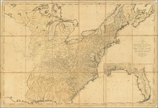
An early example of the United States mapped coast to coast. The map is especially interesting west of the Mississippi, where it shows a double wide Arkansa Territory, Oregon Territory extending from the Mississippi to the Paicfic, early regional reference to Texas, two Salt Lakes w/two rivers flowing to the Pacific, fabulous detail in the Pacific Northwest relying upon Lewis & Clark and the Hudson's Bay Co writings, etc. The map is one of the most detailed renderings of the drainage systems of the Rockies and Upper Mississippi prior to Nicollet. Several early forts are shown in Texas. The Missions and early mythical rivers shown in California. Not in Wheat. A flawless wide margin example.
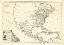
Andre Hubert Brué was a French geographer and cartographer. Born in Paris, he served in the French Navy, joining the Baudin expedition to the Pacific (1800-1804). After his sea service, Brué applied his navigation and charting skills to creating finely-crafted maps, which were renowned for their crisp engraving and accuracy. He drew directly on the copper of the plate, creating what he called encyprotypes. He is best known for the Atlas universal de géographie physique, politique, ancienne et moderne.
![[1958 World's Fair] The United States The Land of the People / Les Etats-Unis Le Pays et ses Habitants / De Verenigde Staten hed Land en het Volk](https://storage.googleapis.com/raremaps/img/small/76701.jpg)