|
||

|

|
|

|
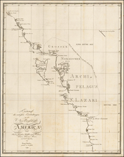
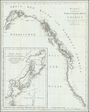
One of the Earliest Maps of Alaska / Russian America -- 42 Years Prior to Its Acquisition by the US
Scarce map of Russian America, being perhaps the first separate map of the region which would become Alaska.
The region extends south to Queen Charlotte's Island and includes some modest detail in the interior mountains. The map is a fascinating look at the region, shortly after Vancouver and La Perouse. Much of the coastline above the Bering Straits is still unexplored. While the map is in the same format as maps issued by Carey & Lea's American Atlas, the Carey & Lea did not include a map of Alaska.
An essential map for Alaska collectors.
Jean Alexandre Buchon (1791-1849) was a French scholar and historian. Born as the French Revolution raged, Buchon was dedicated to recovering France’s history in order to help the country heal and grow. He gathered French stories and published them as part of Collection des chroniques nationales franciases ecrites en langue vulgaire, du XIe au XVIe siècle (4 vols, 1824-1829). He also compiled and published an exploration collection and several histories, particularly about medieval France.
For geography, his most important contribution was publication of the French edition of Carey & Lea’s American Atlas in 1825. Each page of the atlas includes highly detailed text about the state or territory depicted, as well as a map of the area. The French edition is generally considered in high regard as compared to other editions, as it has quality paper and superior engraving.
![[ Pacific Northwest - Northwest Passage ] Limes Occidentis Quivira et Anian. 1597](https://storage.googleapis.com/raremaps/img/small/71207.jpg)