
The item illustrated and described below is sold, but we
have another example in stock. To view the example which
is currently being offered for sale, click the
"View Details" button below.


|
||

|

|
|

|
Stock# 61781
Description
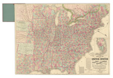
Early map of the United States, colored by regions and Colonies.
The map was published shortly after independence, and prior to the admission of Kentucky, Tennessee or Vermont as states, although Vermont is named quite curiously, appearing above "Hampshire."
Both East and West Florida are shown. Many Indian tribes shown.

![Louisiana [Large-Paper Example]](https://storage.googleapis.com/raremaps/img/small/83278.jpg)