This item has been sold, but you can enter your email address to be notified if another example becomes available.


|
||

|

|
|

|
Stock# 61700
Description
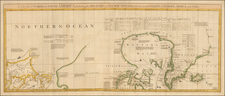
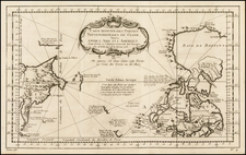
Detailed plan of Port des Francais (Lituya Bay, Alaska), from the Atlas Du Voyage De La Pérouse.
Located in today's Glacier Bay National Park,
The map is from the official account of the voyages of La Pérouse who set sail from France in 1785 to continue the discoveries of Captain Cook. He was shipwrecked in 1788 and died during the voyage, but his narrative, maps, and views survived and were published in 1797. Thirty-eight years later the scattered remains of La Boussole and L'Astrolabe was discovered wrecked on a vicious reef on an atoll in the New Hebrides.
![[St. Lawrence Island, Alaska] Карта Острова св: Лаврентия исправленная колониальными мореходами [Map of the Island of St. Lawrence corrected by the colonial sailors.]](https://storage.googleapis.com/raremaps/img/small/59917.jpg)