|
||

|

|
|

|
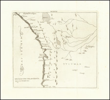
Finely executed map of the area around La Paz and the eastern part of Lake Titicaca, extending north to the Rio Mapiri and Rio Beni regions, published by the Royal Geographical Society.
The map illustrates the expedition of William Martin Conway, 1st Baron Conway of Allington.
William Martin Conway, 1st Baron Conway of Allington (1856 – 1937), known between 1895 and 1931 as Sir Martin Conway, was an English art critic, politician, cartographer and mountaineer, who made expeditions in Europe as well as in South America and Asia.
In 1872 he took up mountain climbing and went on expeditions to Spitsbergen from 1896 to 1897 and the Bolivian Andes in 1898.
In Bolivia, he explored and surveyed the Bolivian Andes, climbing "Sorata" (known today as Ancohuma, 21,086 ft and Illimani (21,122 ft.). He also attempted Aconcagua (22,831 ft.) stopping short of the summit by 50-ft and explored Tierra del Fuego making an attempt on Sarmiento.
At the Paris exhibition of 1900 he received the gold medal for mountain surveys, and the Founders Medal of the Royal Geographical Society in 1905. He served as President of the Alpine Club for 1902–04 and became the first president of The Alpine Ski Club at its inaugural meeting in 1908.
Conway's map was published in Martin Conway, ‘Notes on a map of part of the Cordillera Real of Bolivia’, Geographical Journal 15 (1900): 528–29; and in Martin Conway, The Bolivian Andes: A Record of Climbing and Exploration in the Cordillera Real in the Years 1898 and 1900 (New York, Harper and Bros., 1901).
![[Moxos Plains, Bolivia]](https://storage.googleapis.com/raremaps/img/small/59593.jpg)