This item has been sold, but you can enter your email address to be notified if another example becomes available.


|
||

|

|
|

|
Stock# 61624
Description
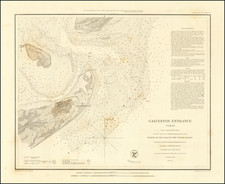
Extremely rare separately published sea chart covering the coast of Texas and Louisiana, published by the United States Hydrographical Office of the U.S. Navy.
Includes the stamp of the original seller, F.W. Lincoln, Jr. & Co. of Boston.
Extends from Matagorda Bay, Galveston Bay and Sabine Lake in the west to New Orleans, Lake Pontchartrain, Bayou la Fourche and Timbalier Bay in the east.
Light houses and soundings are shown.
Rarity
The map is very rare. This is the first time we have ever seen the map for sale.
Condition Description
Moderately toned and soiling. Dampstain along the bottom of the map.
![[San Juan] The Oasis In Texas](https://storage.googleapis.com/raremaps/img/small/92376.jpg)

![(Dallas, Texas) USAF Target Complex Mosaic-Series 25 [Sheets 0 - 4]](https://storage.googleapis.com/raremaps/img/small/87119.jpg)