The item illustrated and described below is sold, but we
have another example in stock. To view the example which
is currently being offered for sale, click the
"View Details" button below.


|
||

|

|
|

|
Stock# 61593
Description
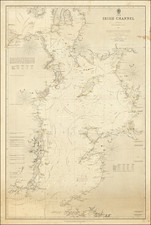
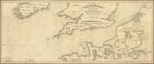
Rare working navigational sea chart, published in London by J.S. Hobbs.
The map covers the English Channel, Bristol Channel and contiguous coasts of Southern Ireland, Southern England and a portion of the coast of France.
Includes a number of profile views.
Condition Description
Blue backed chart. Some soiling,primarily at the left side. Pencil notes referencing Frank P. Hatten in two places. Several other minor blemishes.