


|
||

|

|
|

|
Heightened with Gold Leaf -- Fine Old Color
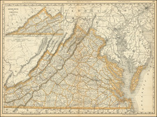
Fine early large-format chart of Chesapeake Bay and the Delaware Estuary, by Pierre Mortier.
This detailed and attractive chart focuses on Chesapeake Bay, and includes all of the Tidewater areas of Virginia and Maryland. It also extends to include all of Delaware, southeastern Pennsylvania, and much of New Jersey. Mortier's chart is considered to be one of the finest obtainable early maps of the region. The Tidewater areas around the Chesapeake are labelled with the names of counties, towns and innumerable plantations. As noted by Morrison, " This large scale map, centered on Maryland and the Chesapeake Bay area, is one of the most beautiful in the history of the cartography of the region."
In 1700, Virginia's tobacco plantations were one of the most important elements of the economy of the British Empire, and the lavish plantation homes which survive to this day are testament to the great wealth of the Virginia Planters. Chesapeake Bay and the Delaware River estuary are both extremely well mapped for the time, and feature a wealth of hydrographic information, including the locations of shoals and depth soundings. This information was of great importance to the plantation owners, as finding the access to the best navigable rivers was a critical element of gaining a trading advantage.
Further to the north is Philadelphia, Pennsylvania. Founded only in 1682, it was the fastest growing city in the American colonies. New Jersey is shown to be divided into East and West Jersey, two separate proprietorships that would exist until New Jersey was united into one state during the American Revolution.
This chart was published by Pierre Mortier (1661-1711), a highly successful Amsterdam publisher. His descendants helped to found the firm of Covens & Mortier, which operated from 1721 to 1866. While born in the Netherlands, Mortier hailed from a French Huguenot family, and maintained extensive contacts in his ancestral homeland.
The present chart was issued as part of the Amsterdam edition of Alexis Hubert Jaillot's Suite du Neptune François, the first comprehensive sea atlas devised in France. The atlas was first issued in Paris in 1693, but did not include the present chart. In the late 1690s, Jaillot, the Royal Geographer to Louis XIV, decided to create an expanded edition of the Neptune, carefully selecting his cartographic sources. In devising the present map, he employed John Thornton and William Fisher's chart which appeared in the first edition of The English Pilot, The Fourth Book (London, 1689). This chart, in turn, was derived from Augustine Herrman's masterly map of Maryland (first published in 1673), considered to be one of the finest maps of American Colonial cartography. In 1700, Jaillot, impressed by the quality and relatively low printing costs offered by Mortier, commissioned the Amsterdam publisher to issue the new edition of the atlas. The present chart was never reissued, making the present chart the only state of the map.
Mortier's chart is an essential map for Chesapeake Bay, Virginia and Maryland collectors.
Pierre, or Pieter, Mortier (1661-1711) was a Dutch engraver, son of a French refugee. He was born in Leiden. In 1690 he was granted a privilege to publish French maps in Dutch lands. In 1693 he released the first and accompanying volume of the Neptune Francois. The third followed in 1700. His son, Cornelis (1699-1783), would partner with Johannes Covens I, creating one of the most important map publishing companies of the eighteenth century.

![(Powhatan Burial Practices) Regulorum Sepulcra XXII [Tombs of the Rulers]](https://storage.googleapis.com/raremaps/img/small/99647.jpg)
![[ Virginia / Mouth of the Chesapeake Bay ] A Draught of Virginia from the Capes to York in York River and to Kuiquotan or Hamton in James River by Mark Tiddeman](https://storage.googleapis.com/raremaps/img/small/103814.jpg)

![[British Colonies in America] Carte Qui Contient Une Description Des Iles & Terres Que Les Anglois . . .[maps of Chesapeake, Carolinas, New England, Bermuda, Gulf Coast, Jamaica, Barbadoes & Canada]](https://storage.googleapis.com/raremaps/img/small/61480.jpg)