|
||

|

|
|

|
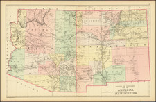
An Early General Land Office Map of New Mexico Territory -- Manuscript Addition of the Jicarilla Apache Reservation
Scarce large format map of New Mexico Territory, published by the General Land Office.
The present example adds the Jicarilla Apache Reservation in Yellow, which had been created by on February 11, 1887, shortly after the printing of the map. In the Mescalero Apache Reservation, the elevation of several mountains are shown
The map shows railroads (completed and proposed), Railroad and Private land grants, military reservations, county boundaries, military and Indian reservations, national forests, confirmed private land claims, boundaries of unconfirmed private land claims, confirmed claims needing new boundary lines, and U.S. reservoirs shown in color.
Also shows status of public land surveys, towns and cities, and railroad lines. Relief is shown by hachures. A nice example of this scarce map.
The General Land Office (GLO) refers to the independent agency in the United States that was in charge of public domain lands. Created in 1812, it assumed the responsibilities for public domain lands from the United States Department of the Treasury. The Treasury had overseen the survey of the Northwest Territory, but as more area was added to the United States, a new agency was necessary to survey the new lands.
Eventually, the GLO would be responsible for the surveying, platting, and sale of the majority of the land west of the Mississippi, with the exception of Texas. When the Secretary of the Interior was created in 1849, the GLO was placed under its authority. Until the creation of the Forest Service in 1905, the GLO also managed forest lands that had been removed from public domain. In additional to managing the fees and sales of land, the GLO produced maps and plans of the areas and plots they surveyed. In 1946, the GLO merged with the United States Grazing Service to become the Bureau of Land Management.